How satellite images and AI could help fight spatial apartheid in South Africa
Townships get little by way of public resources compared with rich suburbs. By mapping the problem, researchers like Raesetje Sefala hope to reverse it.
Raesetje Sefala grew up sharing a bedroom with her six siblings in a cramped township in the Limpopo province of South Africa. The township’s inhabitants, predominantly Black people, had inadequate access to schools, health care, parks, and hospitals.
But just a few miles away in Limpopo, white families lived in big, attractive houses, with easy access to all these things. The physical division of communities along economic and racial lines, so that townships are close enough for the people living there to commute to work but too far to easily access essential services, is just one damaging inheritance from South Africa’s era of apartheid.
The older Sefala became, the more she peppered her father with questions about the visible racial segregation of their neighborhood: “Why is it like this?”
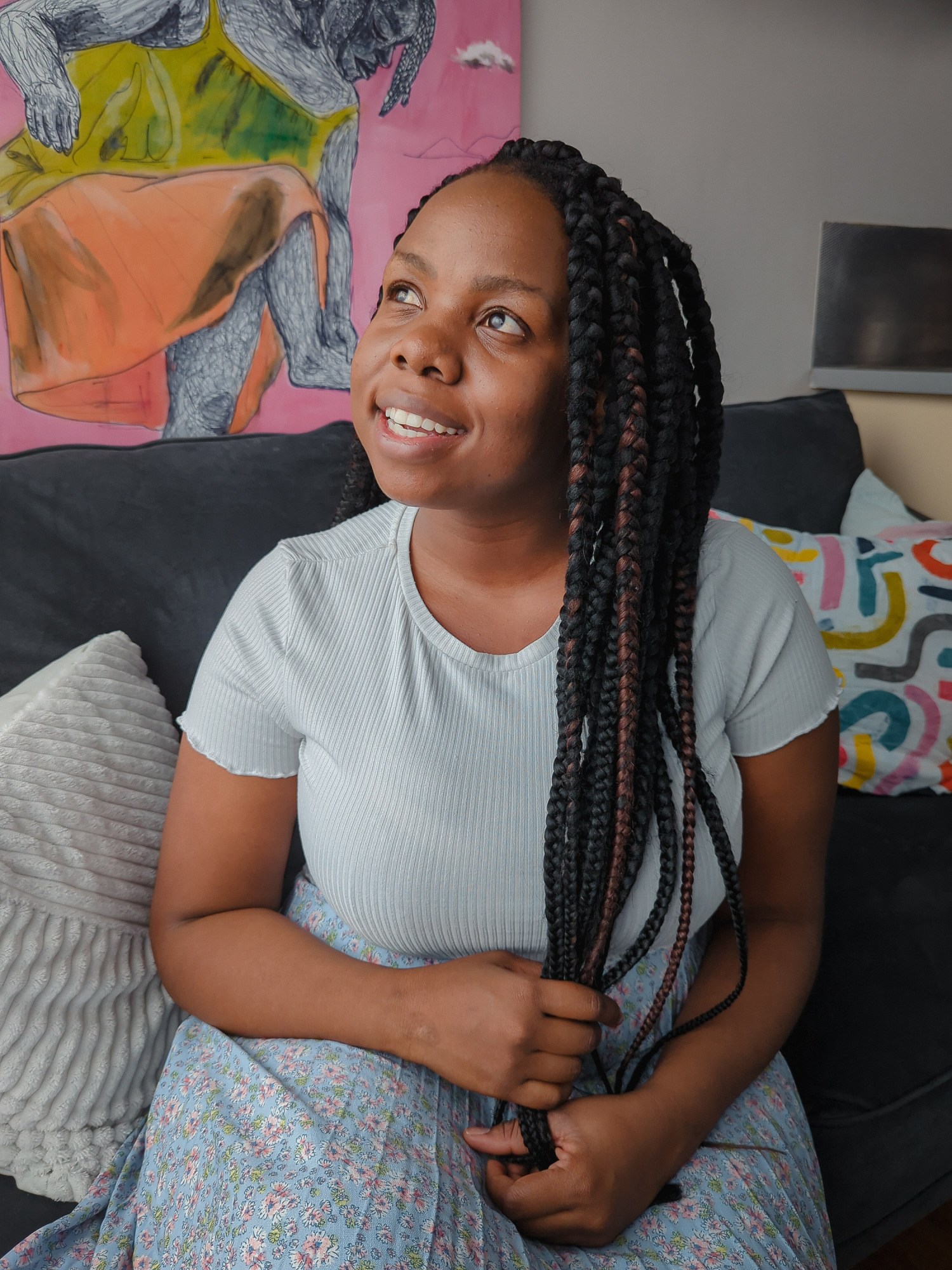
Now, at 28, she is helping do something about it. Alongside computer scientists Nyalleng Moorosi and Timnit Gebru at the nonprofit Distributed AI Research Institute (DAIR), which Gebru set up in 2021, she is deploying computer vision tools and satellite images to analyze the impacts of racial segregation in housing, with the ultimate hope that their work will help to reverse it.
“We still see previously marginalized communities’ lives not improving,” says Sefala. Though she was never alive during the apartheid regime, she has still been affected by its awful enduring legacy: “It’s just very unequal, very frustrating.”
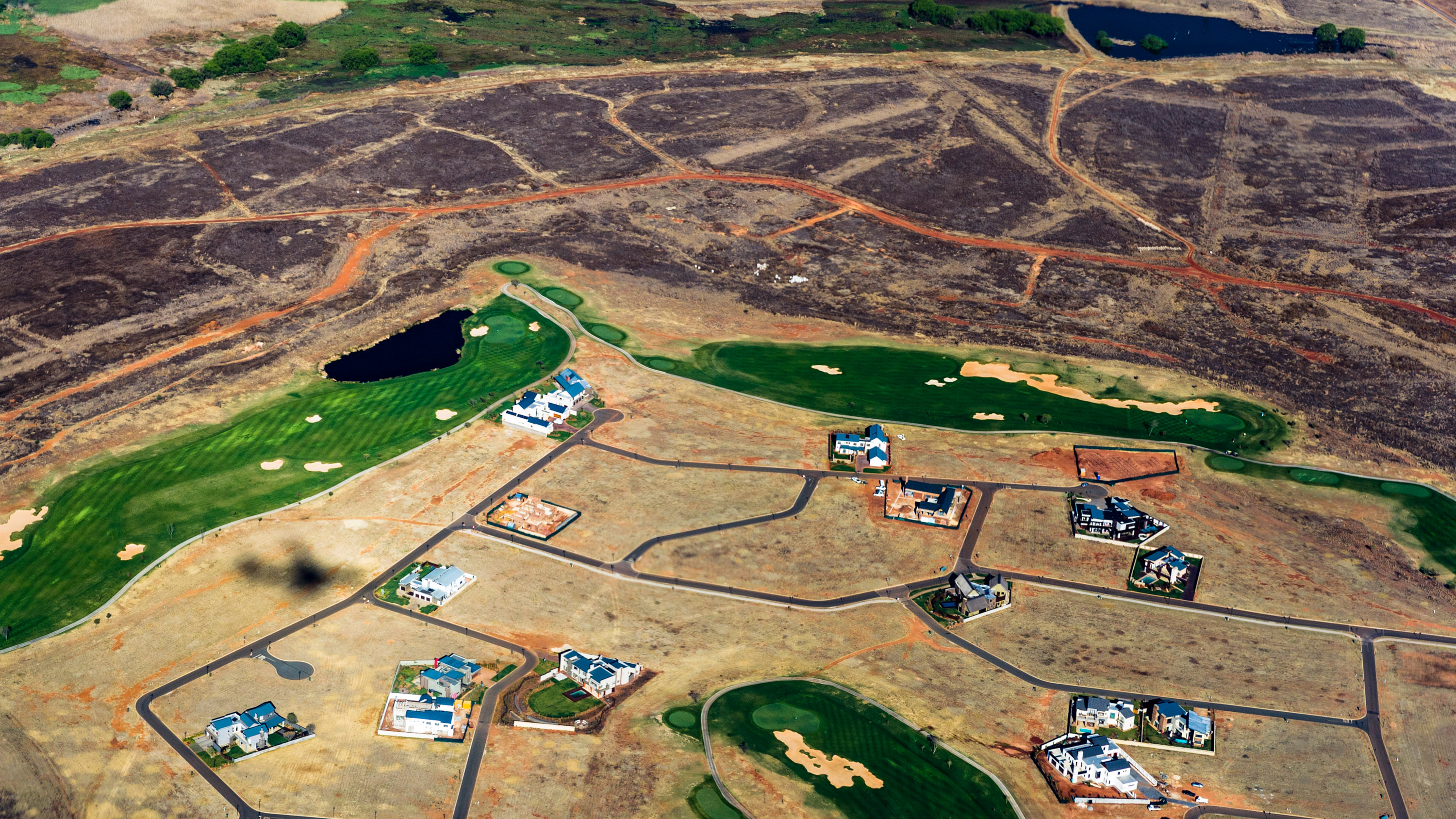
In South Africa, the government census categorizes both wealthier suburbs and townships, a creation of apartheid and typically populated by Black people, as “formal residential neighborhoods.” That census is used to allocate public spending, and when they are lumped together with richer areas, townships are in effect hidden, disproportionately excluding the people living there from access to resources such as health services, education centers, and green spaces. This issue is commonly known as spatial apartheid.
Sefala and her team have spent the last three years building a data set that maps out townships in order to study how neighborhoods are changing in terms of population and size. The hope is that it could help them see whether or not people’s lives in townships have improved since the legal dissolution of apartheid.
They did it by collecting millions of satellite images of all nine provinces in South Africa, and geospatial data from the government that shows the location of different neighborhoods and buildings across the country. Then they used all this data to train machine-learning models and build an AI system that can label specific areas as wealthy, non-wealthy, non-residential, or vacant land.
In 2021, they discovered that over 70% of South African land is vacant, and they saw how much less land is allocated to townships than to suburbs. It was a confirmation of the inequalities they had expected to see, but the staggering quantity of vacant land still took them aback, says Sefala.
Now they’re sharing the data set with researchers and public service institutions, including nonprofits and civic organizations working to identify land that could be used for public services and housing. DAIR plans to make the data set free and accessible on its website from February 2.
“The work fits squarely into our research paradigm to put data using AI into the hands of marginalized groups,” says Gebru.
While dismantling spatial apartheid may take a lifetime, Sefala hopes to use the tools they have developed to fuel systemic change and social justice. “We want the work to push the government to start labeling these townships so that we can begin to tackle real issues of resource allocation,” she says.
Data for change
Moorosi, who now co-advises Sefala at DAIR, first hired her at the South African Council for Scientific and Industrial Research (CSIR) in 2018. Sefala “was absolutely brilliant and fully understood the concept of machine learning,” she says. And Moorosi made her realize that she was not alone in worrying about the impacts of spatial apartheid and neighborhood segregation.
South Africa is the world’s most unequal country, according to the World Bank. Nearly three decades after the end of apartheid, its brutal legacy continues to rob millions of Black South Africans of basic rights, including jobs, education, and access to health care. “It impacts every aspect of people’s lives,” says Nick Budlender, an urban policy researcher at Ndifuna Ukwazi, a nonprofit that advocates for urban land justice in Cape Town.
Sefala’s work is beginning to make its way into the hands of South African institutions and researchers. Earlier this month, DAIR shared its data with a South African policy think tank, the Human Sciences Research Council (HSRC), which is using the information to advise the government on budget allocations for HIV treatment programs across the country. “If they don’t know where the townships are—how fast the population is growing—it makes it difficult for them to allocate resources that are realistic,” says Sefala.
But perhaps the biggest impact her work could have would be to help provide information to organizations fighting for justice in urban planning, especially in the face of South Africa’s worsening housing crisis. For example, in Cape Town, the most racially segregated city in the world, about 14% of households live in informal settlements—unplanned areas without adequate shelter and infrastructure. If some of the vast tracts of public land were turned into affordable public housing, many people would not have to live in informal settlements, advocates say.
However, the lack of publicly available information on public land in the city perpetuates a government myth that the city lacks vacant land.
“We have a real dearth of quality data,” says Budlender, and that makes it a lot harder to advocate for the use of public land to build public housing and services like hospitals. Last September, after five years of research, Ndifuna Ukwazi launched a digital interactive map, known as the People’s Land Map, displaying 2,700 parcels of vacant and underutilized public land in Cape Town.
Its aim is to demonstrate that there’s ample public land available to help address the housing crisis. “When we have called for the development of affordable housing, the government has often responded by saying that there isn’t land available. By developing the map we have conclusively proven that this isn’t the case,” says Budlender.
Sefala says that they hope to share their data to support the work of Ndifuna Ukwazi. And Budlender is excited about the possibilities it could open. “It offers a real opportunity to track and show evidence on how townships are changing, and to shape policy,” he says. “Policy is only ever as good as the data that it is based on.”
These days Sefala travels all over South Africa, giving talks to policymakers, advocates, and students. When she walks through the streets of Johannesburg, she often stops and stares at the huge gated houses and ponders the difference between townships and rich neighborhoods.
“Townships are terribly poor, and it was part of my reality,” she says. “But I’m happy doing something about it.”
Deep Dive
Artificial intelligence
Large language models can do jaw-dropping things. But nobody knows exactly why.
And that's a problem. Figuring it out is one of the biggest scientific puzzles of our time and a crucial step towards controlling more powerful future models.
Google DeepMind’s new generative model makes Super Mario–like games from scratch
Genie learns how to control games by watching hours and hours of video. It could help train next-gen robots too.
What’s next for generative video
OpenAI's Sora has raised the bar for AI moviemaking. Here are four things to bear in mind as we wrap our heads around what's coming.
Stay connected
Get the latest updates from
MIT Technology Review
Discover special offers, top stories, upcoming events, and more.