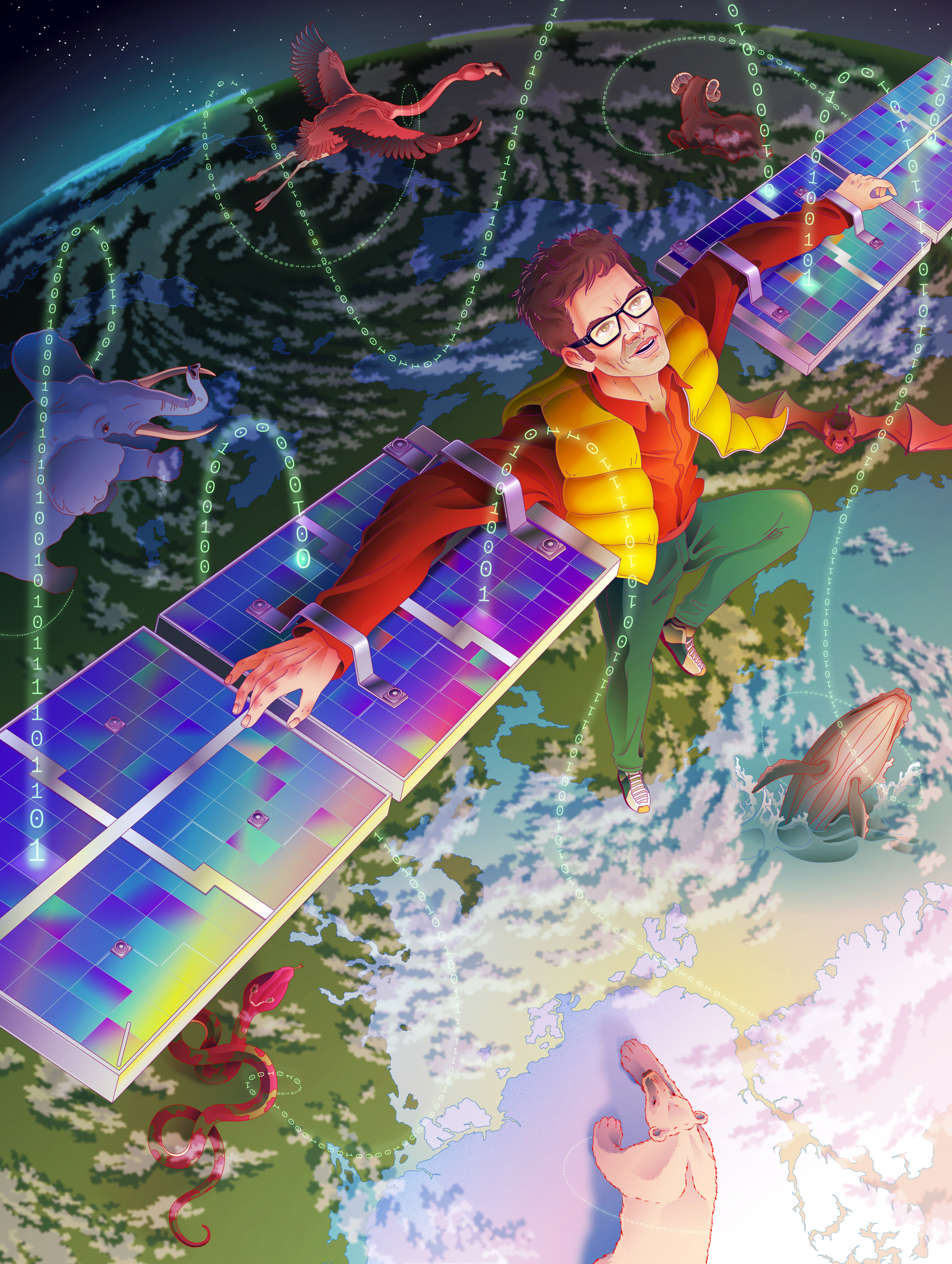
How tracking animal movement may save the planet
Researchers have been dreaming of an Internet of Animals. They’re getting closer to monitoring 100,000 creatures—and revealing hidden facets of our shared world.
There was something strange about the way the sharks were moving between the islands of the Bahamas.
Tiger sharks tend to hug the shoreline, explains marine biologist Austin Gallagher, but when he began tagging the 1,000-pound animals with satellite transmitters in 2016, he discovered that these predators turned away from it, toward two ancient underwater hills made of sand and coral fragments that stretch out 300 miles toward Cuba. They were spending a lot of time “crisscrossing, making highly tortuous, convoluted movements” to be near them, Gallagher says.
It wasn’t immediately clear what attracted sharks to the area: while satellite images clearly showed the subsea terrain, they didn’t pick up anything out of the ordinary. It was only when Gallagher and his colleagues attached 360-degree cameras to the animals that they were able to confirm what they were so drawn to: vast, previously unseen seagrass meadows—a biodiverse habitat that offered a smorgasbord of prey.
The discovery did more than solve a minor mystery of animal behavior. Using the data they gathered from the sharks, the researchers were able to map an expanse of seagrass stretching across 93,000 square kilometers of Caribbean seabed—extending the total known global seagrass coverage by more than 40%, according to a study Gallagher’s team published in 2022. This revelation could have huge implications for efforts to protect threatened marine ecosystems—seagrass meadows are a nursery for one-fifth of key fish stocks and habitats for endangered marine species—and also for all of us above the waves, as seagrasses can capture carbon up to 35 times faster than tropical rainforests.
Animals have long been able to offer unique insights about the natural world around us, acting as organic sensors picking up phenomena that remain invisible to humans. More than 100 years ago, leeches signaled storms ahead by slithering out of the water; canaries warned of looming catastrophe in coal mines until the 1980s; and mollusks that close when exposed to toxic substances are still used to trigger alarms in municipal water systems in Minneapolis and Poland.
These days, we have more insight into animal behavior than ever before thanks to sensor tags, which have helped researchers answer key questions about globe-spanning migrations and the sometimes hard-to-reach places animals visit along the way. In turn, tagged animals have increasingly become partners in scientific discovery and planetary monitoring.
But the data we gather from these animals still adds up to only a relatively narrow slice of the whole picture. Results are often confined to silos, and for many years tags were big and expensive, suitable only for a handful of animal species—like tiger sharks—that are powerful (or large) enough to transport them.
This is beginning to change. Researchers are asking: What will we find if we follow even the smallest animals? What if we could monitor a sample of all the world’s wildlife to see how different species’ lives intersect? What could we learn from a big-data system of animal movement, continuously monitoring how creatures big and small adapt to the world around us? It may be, some researchers believe, a vital tool in the effort to save our increasingly crisis-plagued planet.
Wearables for the wild
Just a few years ago, a project called ICARUS seemed ready to start answering the big questions about animal movement.
A team led by Martin Wikelski, a director at the Max Planck Institute of Animal Behavior in southern Germany and a pioneer in the field, launched a new generation of affordable and lightweight GPS sensors that could be worn by animals as small as songbirds, fish, and rodents.
These Fitbits for wild creatures, to use Wikelski’s analogy, could produce live location data accurate to a few meters and simultaneously allow scientists to monitor animals’ heart rates, body heat, and sudden movements, plus the temperature, humidity, and air pressure in their surroundings. The signals they transmitted would be received by a three-meter antenna affixed to the International Space Station—the result of a €50 million investment from the German Aerospace Centre and the Russian Space Agency—and beamed down to a data bank on Earth, producing a map of the animals’ paths in close to real time as they crisscrossed the globe.
Wikelski and his peers hoped the project, formally the International Cooperation for Animal Research Using Space, would provide insights about a much wider variety of animals than they’d previously been able to track. It also aimed to show proof of concept for Wikelski’s dream of the past several decades: the Internet of Animals—a big-data system that monitors and analyzes animal behavior to help us understand the planet and predict the future of the environment.
Researchers have been laying the groundwork for years, connecting disparate data sets on animal movement, the environment, and weather and analyzing them with the help of AI and automated analytics. But Wikelski had his sights on something even grander and more comprehensive: a dashboard in which 100,000 sensor-tagged animals could be simultaneously monitored as near-real-time data flowed in from Earth-imaging satellites and ground-based sources.
By bringing together each of these snapshots of animals’ lives, we might begin to understand the forces that are shaping life across the planet. The project had the potential to help us better understand and conserve the world’s most vulnerable species, showing how animals are responding to the challenges of climate change and ecosystem loss. It also promised another way to monitor the Earth itself during a period of increasing instability, transforming our animal co-inhabitants into sentinels of a changing world.
When ICARUS first went into space in 2018, it was widely celebrated in the press. Yet what should have been a moment of glory for Wikelski and the field of animal ecology instead became a test of his will. The ICARUS antenna first went down for a year because of a technical issue; it went back up but was only just out of testing in February 2022 when the Russian invasion of Ukraine halted the project altogether.
Wikelski and his peers, though, have used the time since to innovate and evangelize. They now envision a more complete and technologically advanced version of the Internet of Animals than the one they hoped to build even just a few years ago, thanks to innovations in tracking technologies and AI and satellite systems. They have made even smaller and cheaper sensors and found a new, more affordable way to work in space with microsatellites called CubeSats. Their efforts have even gotten NASA to invest its time and resources into the possibility of building the Internet of Animals.
Now Wikelski and his collaborators are again on the verge, with an experimental CubeSat successfully transmitting data as part of a testing phase that started last June. If all goes as planned, another fully operational ICARUS CubeSat will begin collecting data next year, with more launches to follow.
The potential benefits of this system are extraordinary and still not yet fully understood, says Scott Yanco, a researcher in movement ecology at the University of Michigan. Perhaps it could help prevent mountain lion attacks or warn about a zoonotic disease about to make a jump to humans. It could alert researchers of behavioral changes that seem to happen in some animals before earthquakes, a phenomenon Wikelski has studied, and determine what conditions tell boobies in the Indo-Pacific to lay fewer eggs in years before strong El Niños or signal to weaver birds in the Niger Delta to build their nests higher up before floods.
“You can talk to 100 scientists about this,” Yanco says, “and they’re all going to give you a different answer of what they’re interested in.”
But first, a lot still needs to go right.
Animals as sentinels
When I first spoke with Wikelski, in early 2022, ICARUS was live, tracking 46 species from the ISS 400 kilometers overhead. Wearing a pair of square-rimmed glasses and speaking in a German accent with a tone of unfailing urgency, he was excited to tell me about a tagged blackbird who made a 1,000-or-so-kilometer crossing from Belarus to Albania.
That was actually pretty routine, Wikelski said, but almost everything else he had been seeing over the past year of road-testing had been stranger than expected. White storks were crossing back and forth over the Sahara five times a season, without apparent reason. Cuckoos, which are tree-dwelling birds ill suited to long periods at sea, were making uninterrupted journeys from India to the Horn of Africa. “Now, any time you look, totally novel aspects appear, and novel connections appear across continents,” he told me.
This could have been a mystifying mess. But for Wikelski, it was “beautiful data.”
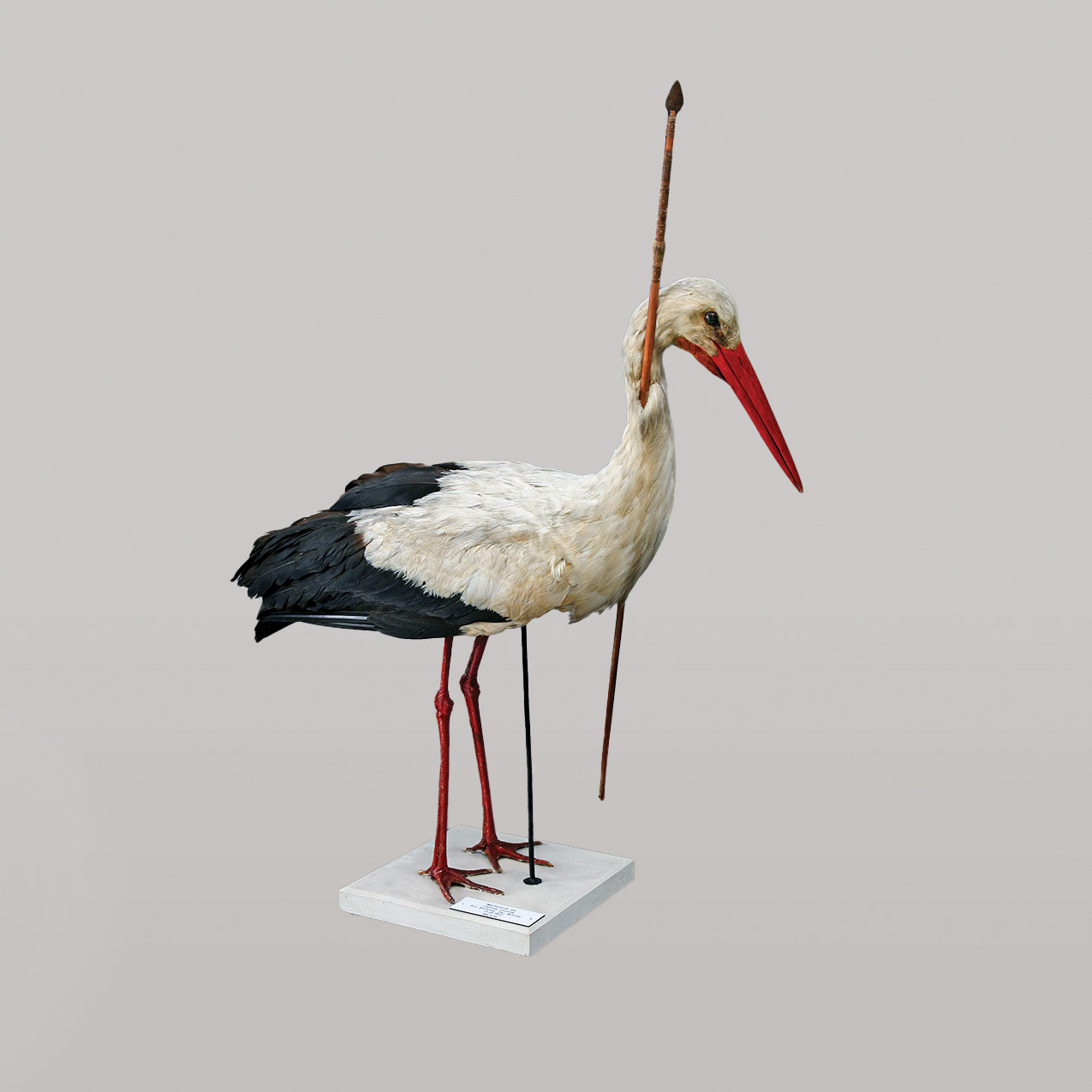
The practice of tagging animals to monitor their movements has been used for more than 100 years, though it began with a stroke of luck. In the 1820s, a hunter in a village in central Africa threw a 30-inch spear that lodged itself nonfatally in the neck of a white stork. This became what might have been the world’s first tag on a wild animal, says Yanco: the bird somehow flew back to Germany in the spring, helping settle the mystery of where storks disappeared to in the winter.
By the 1890s, scientists had started tracking wild birds with bands fitted around their legs—but 49 out of every 50 ring-tagged birds were never seen again. Starting in the 1960s, thousands of birds received very-high-frequency radio tags known as “pingers,” but these were only powerful enough to broadcast a few kilometers. To capture the data, researchers had to embark on cartoonish chase scenes, in which tagged birds were pursued by an oversize homing antenna pointed out the roof of a car, plane, or hang-glider.

Wikelski tried all three. During a stint at the University of Illinois in Urbana-Champaign in the mid-’90s, he was studying thrushes and would gun an Oldsmobile around the Midwest at over 70 miles per hour. He’d set off as the songbirds got going at around 2 a.m., which tended to draw the attention of local police. Wikelski found that contrary to the conventional wisdom, thrushes used just 29% of their energy on their overnight migrations, less than they expended hunting and sheltering during stopovers. But the hassle of his process, which also entailed capturing and recapturing birds to weigh them, convinced Wikelski that, among other things, he needed better tools.
Thinking bigger (and higher)
It was not immediately clear that the solution to Wikelski’s problems would be in space, though the idea of tracking animals via satellite had been explored decades before his Oldsmobile experiments.
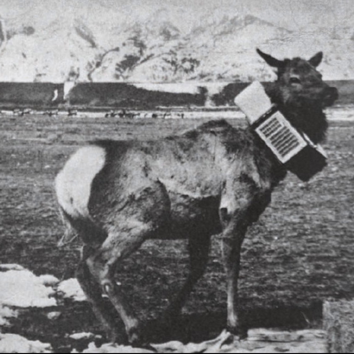
In fact, NASA invented space-based animal tracking back in 1970 when it strapped a transmitter collar the weight of two bowling balls around the neck of Monique the Space Elk, a local news celebrity at the time. (Monique was actually two elks: the anointed Monique, who wore a dummy collar for testing and press photos, and another, who accidentally caught a misfired tranquilizer dart and subsequently got the satellite transmitter collar.) After the Moniques met untimely deaths—one from starvation, the other at the hands of a hunter—the project went dormant too.
But its research lived on in Argos, a weather monitoring system established in 1978 by the National Oceanic and Atmospheric Administration (NOAA) and the French space agency. It pioneered a way to track a tagged animal’s location by beaming up a short stream of analog data and measuring wave compression—the so-called Doppler shift—as a polar-orbiting satellite zoomed overhead at thousands of miles an hour. But this captured locations to only a few hundred meters, at best, and typically required a clear line of sight between tag and satellite—a challenge when working with animals below the canopy of rainforests, for instance.
Wikelski worked extensively with Argos but found that the technology didn’t enable him to capture the highly detailed whole-life data he craved. By the late ’90s, he was on an island in Panama, exploring an alternative approach that followed hundreds of animals from 38 species, including small mammals and insects.
Using six long-distance radio towers, Wikelski and Roland Kays, now the director of the Biodiversity Laboratory at the North Carolina Museum of Natural Sciences, started to develop the Automated Radio Telemetry System (ARTS), a radio collar tracking system that could penetrate thick canopy. Crucially, ARTS revealed interactions between species—for example, how predatory ocelots support the island’s palm trees by eating large quantities of rabbit-like agoutis, after the rodents bury palm seeds underground as a snack for later. The researchers also found that despite what everyone believed, many of the animal inhabitants don’t remain on the island year-round, but frequently travel to the mainland. Kays and Wikelski had demonstrated in microcosm the kinds of insights that fine-grained multispecies tracking could provide even in challenging environments.
But Wikelski was frustrated that he couldn’t follow animals off the map. “If we don’t know the fate of an animal, we will never be able to really do good biology,” he says. The only solution would be to have a map with no edge.
This was around the time that GPS trackers became small enough to be used in animal tags. While radio tags like those used by Argos estimated location by transmitting signals to receivers, GPS systems like those in cars download data from three or more satellites to triangulate location precisely.
Wikelski became a man possessed by the idea of using this technology to create a truly global animal monitoring system. He envisioned digital tags that could capture GPS data throughout the day and upload packets of data to satellites that would periodically pass overhead. This idea would generate both excitement and a lot of skepticism. Peers told Wikelski that his dream system was unrealistic and unworkable.
At the turn of the millennium, he took a position at Princeton with the notion that the institutional pedigree might earn an audience for his “crazy” idea. Not long after he arrived, the chief of NASA’s Jet Propulsion Laboratory came for a talk, and Wikelski asked whether the agency would benefit from a satellite system that could track birds. “He looked at me as if I came from a different planet,” Wikelski remembers. Still, he got a meeting with NASA—though he says he was laughed out of the building. By this time, the agency had apparently forgotten all about Monique.
Undeterred, in 2002 Wikelski launched ICARUS, a half-joke (for fans of Greek mythology) at his own immodest ambitions. It aimed to use digital GPS tags and satellites that would relay the information to a data center on Earth nearly as instantly as the ARTS system had.
Wikelski’s big ideas continued to run into big doubts. “At the time, people told us technology-wise, it will never work,” he says. Even 10 years ago, when Wikelski was making proposals to space agencies, he was told to avoid digital tech altogether in favor of tried-and-tested Argos-style communication. “Don’t go digital!” he recalls people telling him. “This is completely impossible! You have to do it analog.”
Moving away from the fringe
In the two decades since ICARUS was established, the scientific community has caught up, thanks to developments in consumer tech. The Internet of Things made two-way digital communications with small devices viable, while lithium batteries have shrunk to sizes that more animals can carry and smartphones have made low-cost GPS and accelerometers increasingly available.
“We’re going from where we couldn’t really track most vertebrate species on the planet to flipping it. We’re now able to track most things,” says Yanco, emphasizing that this is possible “to varying degrees of accuracy and resolution.”
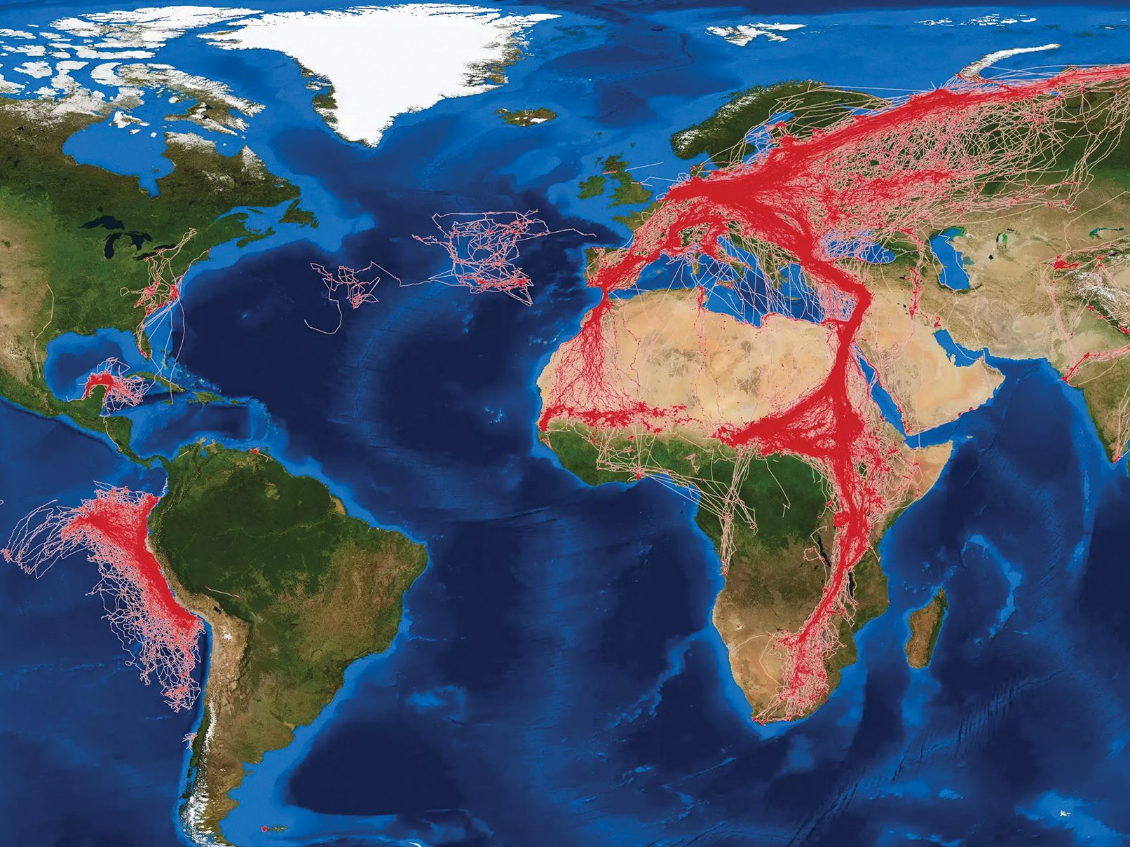
The other key advance has been in data systems, and in particular the growth of Movebank, a central repository of animal tracking data that was developed from Wikelski’s ARTS system. Movebank brings together terrestrial-animal tracking data from various streams, including location data from the Argos system and from new high-res digital satellites, like ICARUS’s antenna on the ISS. (There are also plans to incorporate CubeSat data.) To date, it has collected 6 billion data points from more than 1,400 species, tracking animals’ full life cycles in ways that Wikelski once could only dream about. It is now a key part of the plumbing of the animal internet.
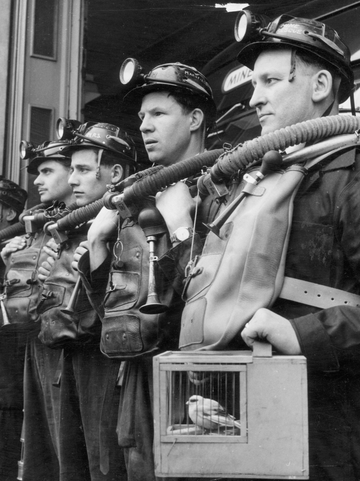
The field also had some practical successes, which in turn allowed it to marshal additional resources. In 2016 in London, for instance, where air pollution was responsible for nearly 10,000 human deaths a year, researchers from Imperial College and the tech startup Plume Labs released 10 racing pigeons equipped with sensors for nitrogen dioxide and ozone emissions from traffic. Daily updates (tweeted out by the Pigeon Air Patrol account) showed how taking a pigeon’s path through the neighborhoods revealed pollution hot spots that weather stations missed.
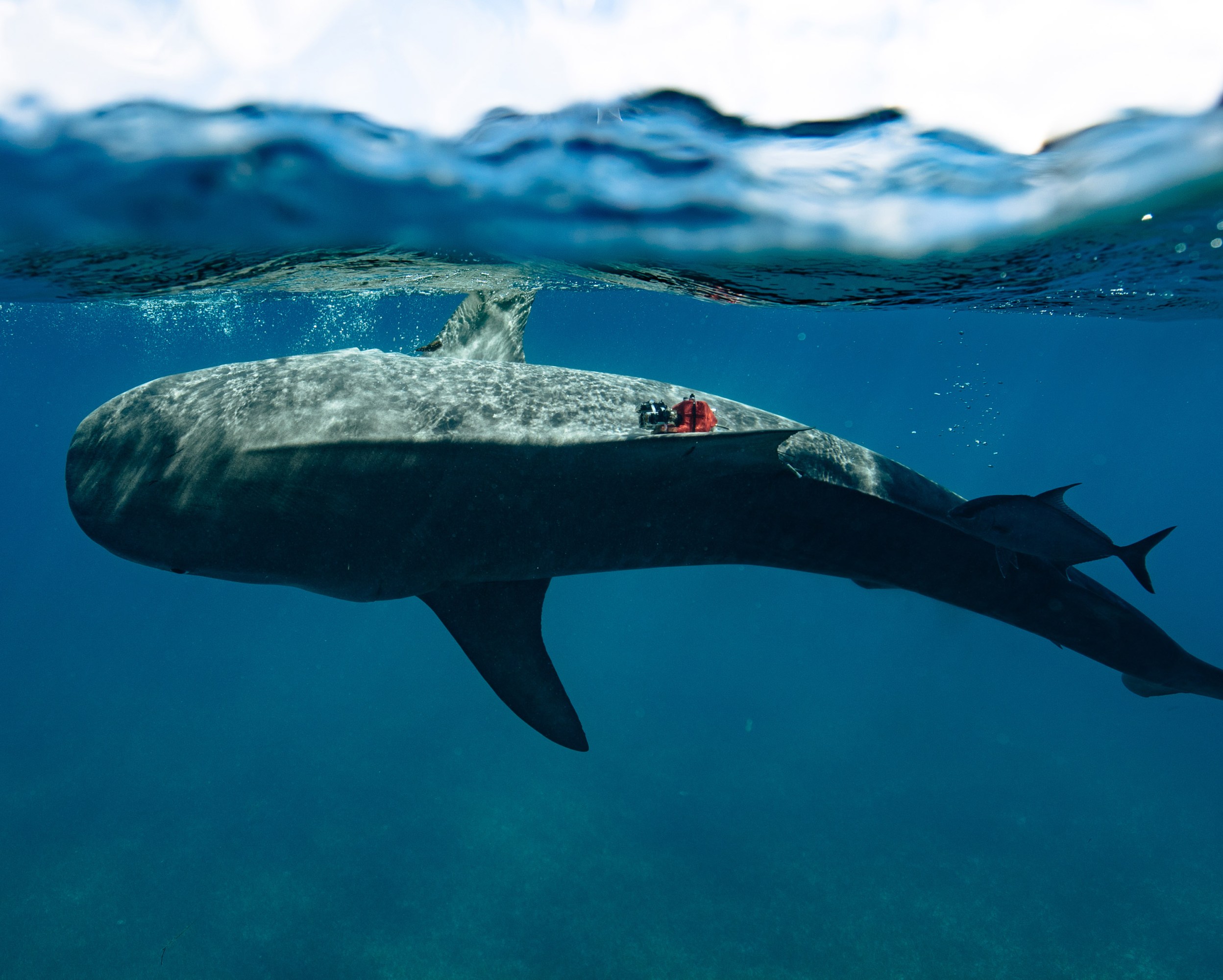
Diego Ellis Soto, a NASA research fellow and a Yale PhD candidate studying animal ecology, highlights an experiment from 2018: flocks of storks were outfitted with high-resolution GPS collars to monitor the air movements they encountered over the open ocean. Tagged storks were able to capture live data on turbulence, which can be notoriously hard for airlines to predict.
Among the critical roles for these animal sensors was one that was once considered eccentric: predicting weather and the world’s fast-changing climate patterns. Animals equipped with temperature and pressure sensors essentially act as free-roaming weather buoys that can beam out readings from areas underserved by weather stations, including polar regions, small islands, and much of the Global South. Satellites struggle to measure many environmental variables, including ocean temperatures, which can also be prohibitively expensive for drones to collect. “Eighty percent of all measurements in Antarctica of sea surface temperature are collected by elephant seals, and not by robots or icebreakers,” Ellis Soto says. “These seals can just swim underneath the ice and [do] stuff that robots can’t do.” The seals are now tagged yearly, and the data they collect helps refine weather models that predict El Niño and sea-level rise.
When the ICARUS antenna was installed on the ISS in August 2018, it seemed poised to unlock even more capabilities and discoveries. In the antenna’s short life, the project recorded the movements of bats, birds, and antelope in near-real time, from Alaska to the islands of Papua New Guinea, and transferred the data to Movebank. But when the experiment ground to a premature halt, Wikelski knew he’d have to do something different, and he concocted a plan by which ICARUS could continue—whether it could rely on a major space agency or not.
Another shot
Rather than a system of major satellites, the new incarnation of ICARUS will run on CubeSats: low-cost, off-the-shelf microsatellites launched into low Earth orbit (around the same height as the ISS) for around $800,000, meaning even developing nations that harbor space ambitions can be part of the project. CubeSats also offer the benefit of truly global coverage; the ISS’s orbital path means it can’t pick up signals from polar regions further north than southern Sweden or further south than the tip of Chile.
There’s currently one ICARUS CubeSat in testing, having launched into orbit last summer. If all goes well, a CubeSat funded by the Max Planck Society, in collaboration with the University of the Bundeswehr Munich, will launch next April, followed by another in winter 2025, and—they’re hoping—another in 2026. Each further addition allows the tags to upload once more per day, increasing the temporal resolution and bringing the system closer to truly real-time tracking.
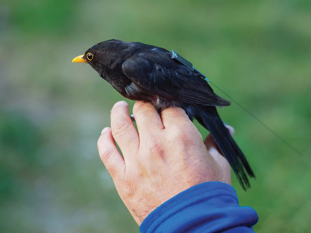
Outfitting even small animals with lightweight, inexpensive GPS sensors, like the one on this blackbird, and monitoring how they move around the world could provide insights into the global effects of climate change.
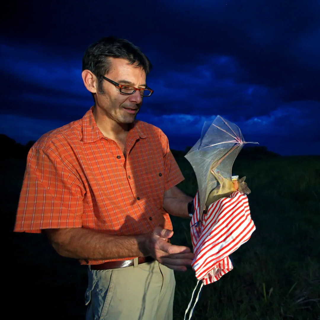
Wikelski and his partners have also rededicated themselves to making even smaller tags. They’re close to the goal of getting them down to three grams, which would in theory make it possible to track more than half of mammal species and around two-fifths of birds, plus hundreds of species of crocodiles, turtles, and lizards. ICARUS’s tags are also now cheaper (costing just $150) and smarter. ICARUS developed AI-on-chip systems that can reduce the energy use by orders of magnitude to cut down on the size of batteries, Wikelski explains. There are also new tags being tested by scientists from the University of Copenhagen and Wikelski’s institute at Max Planck that harvest energy from animal movements, like a self-winding wristwatch. Finally, these new ICARUS sensors can also be reprogrammed remotely, thanks to their two-way Internet of Things–style communications. A new ecosystem of tag makers—professional and DIY—is further driving down prices, open-sourcing innovation, and allowing experimentation.
Still, not everyone has bought into ICARUS. Critics question the costs compared with those of existing terrestrial monitoring initiatives like MOTUS, a national Canadian bird conservation program that uses a network of 750 receiving towers. Others argue that researchers can make better use of the thousands of animals already tracked by Argos, which is upgrading to more accurate tags and is also set to launch a series of CubeSats. The total cost of a fully realized ICARUS system—100,000 animals at any one time, some of which die or disappear as new ones are tagged—is around $10 million to $15 million a year. “If you’re thinking about how to tag a moose or bighorn sheep, you might need to hire a helicopter and the whole team and the vet,” says Ellis Soto, who has long collaborated with Wikelski. “So the costs can be extremely, extremely limiting.”
But, proponents argue, the initiative would beget a lot more information than other Earth-imaging space missions and be significantly cheaper than sending humans or drones to collect data from remote locations like polar ice sheets. Wikelski also emphasizes that no one entity will bear the cost. He is working with local communities in Bhutan, South Africa, Thailand, China, Russia, and Nigeria and gets requests from people across the world who want to connect tags to ICARUS. With cheap satellites and cheap tags, he sees a route to scale.
Even as ICARUS explores a grassroots future, one of the biggest changes since the initial launch is the backing Internet of Animals technology has received from the biggest giant in the field: NASA. The agency is now two years into a five-year project to explore how it might get more involved in building out such a system. “We’re very much focused on developing future mission concepts that will come after the current set of ICARUS missions,” says Ryan Pavlick, a researcher in remote sensing of biodiversity at NASA’s Jet Propulsion Laboratory. In 2024, this will mean “architecture studies” that aim to understand what technical systems might meet the animal-tracking needs of stakeholders including NOAA, the US Fish and Wildlife Service, and the United States Geological Survey.
While NASA’s project aims to deliver benefits for the American people, a fully realized Internet of Animals would necessarily be global and interspecies. When we spoke in November 2023, Wikelski had just got off the phone discussing how ICARUS can help monitor the global “deal for nature” established by the UN’s COP15 biodiversity conference, whose targets include reducing extinction rates by a factor of 10.
Jill Deppe, who leads the National Audubon Society’s Migratory Bird Initiative, has boundless enthusiasm for how an Internet of Animals could affect organizations like hers. For a century, Audubon has watched migratory birds disappear on journeys to Chile or Colombia. A system that could tell us where birds are dying across the entire Western Hemisphere would allow Audubon to precisely target investments in habitat protection and efforts to address threats, she says.
“Our on-the-ground conservation work is all done on a local scale,” says Deppe. For migratory birds, ICARUS can link these isolated moments into a storyline that spans continents: “How do all of those factors and processes interact? And what does that mean for the birds’ survival?”
Movebank’s live-updating dashboard also makes more dynamic conservation action possible. Beaches can be closed as exhausted shorebirds land, wind farms can halt turbines as bats migrate through, and conservation-conscious farmers—who already aim to flood fields or drain them at times that suit migrating flocks—can do so with real knowledge.
In return, will animals really help us see the future of the planet’s climate?
No one is suggesting that animals take over from the system of satellites, weather stations, balloons, and ocean buoys that currently feed into meteorologists’ complex models. Yet technology that complements these dependable data streams, that captures the ever-changing biological signals of seals, storks, sharks, and other species, is already starting to fill in gaps in our knowledge. Once considered cryptic signs from the fates, or harbingers of doom, their behaviors are messages that have only just begun to show us ways to live on a changing planet.
Matthew Ponsford is a freelance reporter based in London.
Deep Dive
Climate change and energy
The problem with plug-in hybrids? Their drivers.
Plug-in hybrids are often sold as a transition to EVs, but new data from Europe shows we’re still underestimating the emissions they produce.
Harvard has halted its long-planned atmospheric geoengineering experiment
The decision follows years of controversy and the departure of one of the program’s key researchers.
Why hydrogen is losing the race to power cleaner cars
Batteries are dominating zero-emissions vehicles, and the fuel has better uses elsewhere.
Decarbonizing production of energy is a quick win
Clean technologies, including carbon management platforms, enable the global energy industry to play a crucial role in the transition to net zero.
Stay connected
Get the latest updates from
MIT Technology Review
Discover special offers, top stories, upcoming events, and more.