First Detailed Public Map of U.S. Internet Backbone Could Make It Stronger
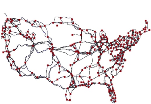
It may not look like much at first glance, but a map created by University of Wisconsin computer science professor Paul Barford and about a dozen colleagues took around four years to produce. He believes it could make the Internet more resilient to accidents, disasters, or intentional attacks.

The map shows the paths taken by the long-distance fiber-optic cables that carry Internet data across the continental U.S. The exact routes of those cables, which belong to major telecommunications companies such as AT&T and Level 3, have not been previously publicly viewable, despite the fact that they are effectively critical public infrastructure, says Barford.
The Department of Homeland Security is making the map and data behind it available through a project called Predict, which offers data relevant to Internet security to government, private, and public researchers. “Our intention is to help improve security by improving knowledge,” says Barford. “I think the map highlights that there are probably many opportunities to make the network more robust.”
Knowing the exact location of the most important Internet cables should help efforts to understand the possible effects of natural disasters or intentional attacks on the Internet, for example. Barford says he is also talking with researchers and people at telecommunications companies about the idea of adding extra fiber links that would be shared by different companies. They’d be located at key points where new fiber between major population centers could significantly improve the resilience and efficiency of the Internet.
Although the Internet is publicly accessible, it is woven together from many privately owned networks that interoperate. Telecommunications companies sometimes show schematics of their core networks, but without much geographic detail. Barford says some government agencies likely have maps of their own, but they aren’t public.
Barford and colleagues compiled their map by drawing on public records created by the permitting process for laying cables. Documents held by county clerks and other bodies record the exact path of cables as they cross public and private land. The map was presented in a paper at the Sigcomm conference on computer networking research last month. The paper was coauthored by Barford and colleagues from the University of Wisconsin, Colgate University, and the network security company Niksun.
Tim Maurer, head of research at the Cyber Security Initiative of the Washington, D.C.-based think tank the New America Foundation, says the new map is valuable. Internet policy is becoming more important to society, but much is not understood about how the network operates. “A lot of discussions in Washington take place in a vacuum of empirical data,” he says. “I see this paper as part of a broader push to have more transparency around Internet policy issues that can inform a broader debate.”
Maurer and Barford also say that knowing the shape of America’s Internet backbone could have implications for the push for net neutrality, the principle that Internet providers must treat all traffic on their networks equally.
In February, the Federal Communications Commission designated Internet providers “common carriers,” meaning that they must make some of their infrastructure available to competitors. That decision has not yet been translated into a policy implementation, and legal and political battles are expected. A better shared understanding of the shape of U.S. Internet infrastructure could make any debate more productive, says Maurer.
Deep Dive
Computing
How ASML took over the chipmaking chessboard
MIT Technology Review sat down with outgoing CTO Martin van den Brink to talk about the company’s rise to dominance and the life and death of Moore’s Law.
How Wi-Fi sensing became usable tech
After a decade of obscurity, the technology is being used to track people’s movements.
Why it’s so hard for China’s chip industry to become self-sufficient
Chip companies from the US and China are developing new materials to reduce reliance on a Japanese monopoly. It won’t be easy.
Stay connected
Get the latest updates from
MIT Technology Review
Discover special offers, top stories, upcoming events, and more.