How Deep Learning Gives Us a Precise Picture of All the Water on Earth
Water levels can indicate the next region that will experience political unrest or where climate change is hitting the hardest. Orbital Insight is monitoring them by applying deep learning to satellite images.
Where exactly is all the water on Earth’s surface? Stand-alone satellite images have their limitations, but using artificial intelligence to examine them can now glean precise levels of water around the world and how they are changing week by week.
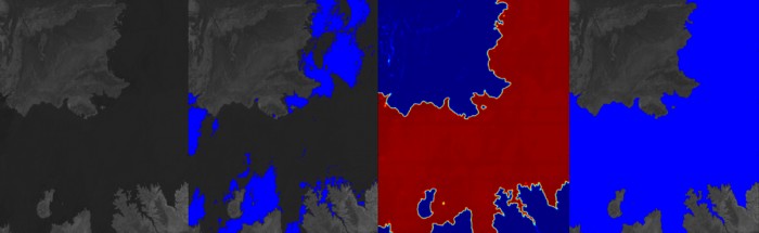
Palo Alto startup Orbital Insight uses freely available images taken by the U.S. Geological Survey’s Landsat 7 and 8 satellites, much like the images you see on Google Maps. The startup feeds the images into a neural network, which pinpoints the exact location and area of surface water.
Advertisement
While it’s not a new feat to track the Earth’s water levels, Orbital Insight is approaching the task with a specially trained neural network that labels water pixel by pixel. The team manually sorted through thousands of images to find examples with clearly and accurately marked water, and then trained the neural network with them.
This story is only available to subscribers.
Don’t settle for half the story.
Get paywall-free access to technology news for the here and now.
“We basically built … Tinder for Landsat maps: Swipe right if it’s good, swipe left if it’s bad,” CEO James Crawford says of the system the researchers used.
As a result, the neural network is especially good at picking up on what’s water and what’s not, whereas other water-detecting systems might identify the shadows of clouds or mountains as water.
Water-level data at this depth could be of interest to many groups. Insurance companies investigating the extent of a flooding event, for instance, or agencies interested in tracking climate change and water levels over the course of the year.
Orbital Insight’s neural network is good at picking up on what’s water and what’s not, whereas other systems might identify the shadows of clouds as water.
Orbital Insight can now label the world’s water every two weeks. Eventually, it will drop that number down to one week.
Steven Glaser, who directs the Citris Intelligent Water Infrastructures and Adaptive Cities Initiative at the University of California, Berkeley, notes that most water models are based on the last 50 years, which may soon make them out-of-date.
“With climate change, these models are becoming moot,” Glaser says. “The more information we can gather as the climate is changing, the better we can model, and better models are needed for the water security of all users.”
Water can also tell us something about the future—droughts can lead to crop failures and displacement. Even nations can squabble over water, leading to political unrest.
Advertisement
“Some of that stress is exacerbated by things like water rights and how the water is shared between various countries,” says Orbital Insight engineering director Shwetank Kumar. “Once you can measure the amount of water available, who is using what, etc., then you can develop a good framework to think about water rights.”