Stitching together a live world map from many different satellite images lets algorithms keep an eye on the health of crops and problems like flooding.
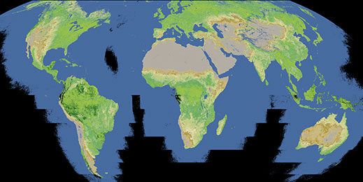
It’s Earth as not even astronauts get to see it—completely without clouds.
A cloud-free view of vegetation patterns across the world, stitched together from data from NASA and other government sources.
Software developed by startup Descartes Labs stitches together daily satellite images into a live map of the planet’s surface and automatically edits out any cloud cover. That makes for a nicer view, and also helps algorithms that automatically track changes in land use or vegetation. The company says its software can make better forecasts of America’s corn crop than the U.S. Department of Agriculture.
Advertisement
Descartes Labs was founded to commercialize image-recognition software developed for satellite and aerial imagery at Los Alamos National Laboratory. The software has been trained to identify features of Earth’s surface such as agriculture, water features, and types of forest by comparing annotated maps from sources like the U.S. Geological Survey with color, infrared, and ultraviolet satellite imagery.
This story is only available to subscribers.
Don’t settle for half the story.
Get paywall-free access to technology news for the here and now.
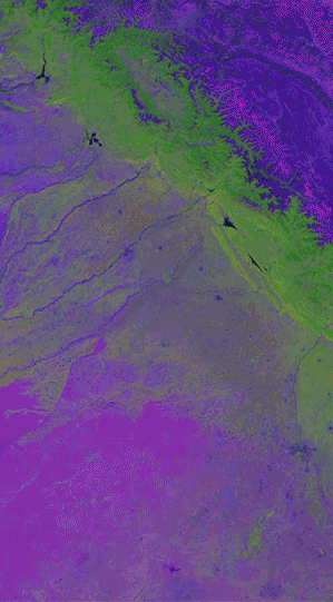
Combining many satellite images makes it possible to watch changes in vegetation, crops, and land use over time, as seen here on the border between China and India. Algorithms can automatically track patterns, for example to predict the possible size of a harvest.
The company has also developed software that stitches together a continuously updated map of Earth from the latest satellite images from NASA and other government sources in other countries. Some imagery used in the map is updated daily.
The Descartes Labs image-recognition software can use that almost-live view to visualize or measure changes such as floods, or changes in the condition of crops. The company uses a machine-learning technique called deep learning, which has led to major advances in image recognition in recent years (see “10 Breakthrough Technologies 2013: Deep Learning”).
Steven Brumby, cofounder and chief technology officer of Descartes Labs, says the technique makes satellite imagery much more useful. “It has never been possible to exploit all this data from NASA and other sources at scale before,” he says.
Brumby says his algorithms can extract valuable signals from satellite snaps. For example, some have been trained to forecast future corn crops based on the color and appearance of the plants in a field. Brumby says analyzing data from the past 11 years shows his predictions are more accurate than those of the USDA, made using data gathered from farmers. He hopes to sell information like that to farmers, suppliers of agricultural equipment, commodities traders, and policy makers.
Measuring the health of vegetation or changes in water distribution could also inform foreign policy, says Brumby. Secretary of State John Kerry suggested last month that several years of drought and poor harvests may have helped precipitate the civil war in Syria.
Descartes Labs is not the only company trying to make money by extracting data from satellite images. Startup Orbital Insight uses deep learning to scrutinize infrastructure such as parking lots and oil storage containers, with the idea that how full they are reveals important economic data (see “Startup Promises Business Insights from Satellite Images”). Last year, Google bought up Skybox Imaging, which offers similar services and even operates its own satellites.
Brumby says his and those other companies will soon be able to expand their offerings because of the rise of small, low-cost “cubesats,” which should soon be snapping images of Earth in great numbers. “There’s going to be an explosion of data,” he says.