Instead of creating a fleet of GPS-type satellites, why not broadcast the signals from the ground and route them through existing communications satellites? Indeed, China has already tested the idea
When it comes to satellite navigation systems, everybody’s gotta have one. The US has the global positioning satellite system, Russia has GLONASS, Europe hopes to have Galileo operational by 2020 and China has a similar timescale for its COMPASS system. Even Japan and India are getting in on the act with QZSS, the Quasi Zenith Satellite System of Japan, and the Indian Regional Navigational Satellite System or IRNSS.
The trouble with all these systems is the huge time and expense required to design, test, build and launch them. The GPS system alone is estimated to have cost $1.5 billion in 2012 alone. Surely there must be a cheaper way to do it.
Advertisement
There sure is, say Hai-Fu Ji and buddies at the National Astronomical Observatories, part of the Chinese Academy of Sciences in Beijing. They point out that satellite navigation systems work using a large number of satellites that all transmit highly accurate time signals.
This story is only available to subscribers.
Don’t settle for half the story.
Get paywall-free access to technology news for the here and now.
Receivers on the ground then compare the arrival times of signals from several different satellites to triangulate their position. The GPS system, for example, has 30 satellites in orbit providing a positioning data to within a few metres.
Hai-Fu and co say a cheaper idea is to transmit the highly accurate time signals from the ground and simply route them through geostationary satellites that are already in orbit. Receivers can then triangulate their position in the same way. That’s much easier and cheaper since it uses existing communications infrastructure
Indeed, China tested this idea in 2005 using communications satellites to provide positioning signals for several Chinese cities.
There is a problem, however. Geostationary satellites sit exactly in the equatorial plane so their signals can only give an east-west position. To get a north-south position requires satellites above and below the equatorial plane.
Today Hai-Fu and pals say they’ve worked out how to do this. Throughout their lives, geostationary satellites are constantly buffeted by a variety of forces that push them off station. These are the result of the Sun and Moon’s gravity, the aspherical shape of the Earth, solar radiation and so on. So these satellites expend most of their fuel keeping station.
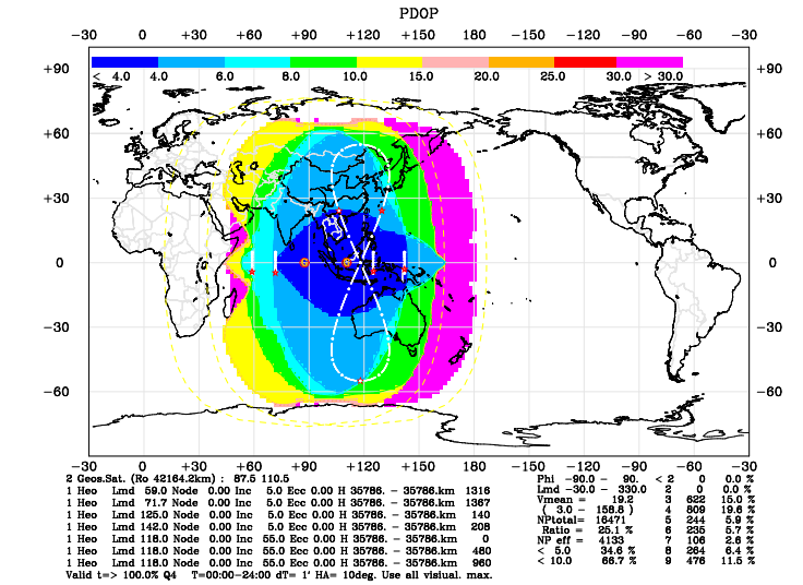
Towards the end of the satellites’ lives, however, operators conserve fuel by keeping station only in the east-west direction. This allows the satellites to move into an inclined plane so that they appear to map out a figure-of-eight shape from the ground.
It is this north-south movement that Hai Fu and pals want to exploit. These guys want to use the communications capabilities of these end of life satellites to broadcast time signals that allow receivers in the ground to triangulate their position in three dimensions.
Advertisement
They say there are various advantages over and above the simplicity and cost. Communications satellites are ideally suited to broadcasting other information too so the positioning signals could be combined with other data such as weather info. The satellites can also broadcast over a range of frequencies which can get around issues of interference. And since the ground-based equipment can always be upgraded to offer state of art time signals, the system would offer a positioning resolution in the centimetre range.
Perhaps most interesting of all, the communications link can be two-way, which would allow users to transmit data too–perhaps their position in times of distress.
Best of all, all this could be tested now at minimum cost. Whether China will go down this route is another question, given its significant investment in the COMPASS system.
However, it’s not beyond the realms of possibility that other countries might take this route–GPS-on-a-shoestring might appeal to an up-and-coming nation. Brazil, perhaps?
Ref: arxiv.org/abs/1211.5412: The Principle of Navigation Constellation Composed of SIGSO Communication Satellites