For the first time, scientists have been able to
watch the deformation and recovery of Earth’s surface over the three-and-a-half years following a devastating earthquake. The researchers studied the aftermath of the 2003 Iranian Bam
earthquake using a European Space Agency (ESA) satellite. Led by Eric Fielding of the Jet
Propulsion Laboratory, California Institute of Technology, the scientists used a remote-sensing technique called interferometric synthetic aperture radar (InSAR) to create images and maps of the region over this period.
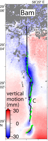

“The most important thing we found is that there is this elongated ditch, like a depression, that formed after the earthquake. It’s very shallow, only six centimeters after the 3.5 years, but it follows exactly along the area where the fault ruptured,” says Fielding. Understanding how damage zones respond to a quake may help predict how buried faults will behave, he adds. The findings were published today in the journal Nature.
Currently, little is known about what happens to Earth’s surface before or after an earthquake. Seismic monitoring using networked sensors, GPS, or ground surveys is only common in areas like California where the frequency of an event is high. In this study, the researchers used satellites to gather raw data and then processed the information into maps using InSAR, which pairs two radar images and measures the difference between every point (every 20 meters) in the images. The technique creates a very high resolution map so that scientists can see how the deformation caused by the earthquake is distributed.
Don’t settle for half the story.
Get paywall-free access to technology news for the here and now.


