MIT Technology Review Subscribe

Flight of Google

A feature within the Google Earth software lets users simulate piloting a plane.

Last week, news hit the blogs that Google Earth provides a flight simulator that allows a user to “fly” over mapped terrain of real places. Here’s an excerpt from a post at Techcrunch:

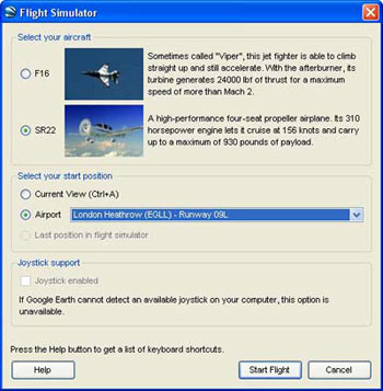
Hidden inside Google Earth is a secret Flight Simulator that takes full advantage of Google’s extensive satellite imagery. To access the hidden feature, open Google Earth and hit Command+Option+A (note it must be capital A) or Ctrl+Alt+A if you’re using a Windows Machine. The Google Earth Flight Simulator comes with two aircraft options, a F16 Viper and the more manageable SR22 4 seater. Players have the option of commencing the game from their current location in Google Earth or can pick from a list of pre-determined runways.

Advertisement

Control instructions are here. Below are screen shots from the flight simulator.

This story is only available to subscribers.

Don’t settle for half the story.
Get paywall-free access to technology news for the here and now.

Subscribe now Already a subscriber? Sign in
You’ve read all your free stories.

MIT Technology Review provides an intelligent and independent filter for the flood of information about technology.

Subscribe now Already a subscriber? Sign in
This is the control panel where users choose the type of plane they will fly, the airport from which they will depart, and whether they will use a joystick to control the plane.
The user stalls (denoted by red type) over the Buenos Aires airpo
The user flies over the airport at Hamburg, German
The user flies over LAX in California
This is your last free story.
Sign in Subscribe now

Your daily newsletter about what’s up in emerging technology from MIT Technology Review.

Please, enter a valid email.
Privacy Policy
Submitting...
There was an error submitting the request.
Thanks for signing up!

Our most popular stories

Advertisement