How Cartographers Digitized the 18th-Century Road Network in France
In 1747, King Louis XV of France ordered the cartographer César-François Cassini de Thury to draw a map of France using the revolutionary new technique of geodesic triangulation. Cassini—the grandson of the astronomer who discovered several moons of Saturn and the division of its rings that bears his name—divided the country into 180 rectangles, each 80 kilometers by 50 kilometers, and started work on a map at a scale of 1:86,400.

So began one of the greatest feats in the history of map-making. The map took more than 50 years to complete and involved four generations of the Cassini family. The resulting work—now known as the Cassini map—consists of 180 plates showing the country at a level of detail that was unprecedented then and is still admired today.
Modern cartographers have another interest in the Cassini map: to help them address some increasingly important questions in urban planning. How does a road network evolve over time? And how does this influence the process of urbanization? The Cassini map provides a unique way to investigate this question since it allows a straightforward comparison between the network that existed then and the one that exists today.
But there is a problem: how to convert a map that is more than 200 years old into a digital form that can be easily compared to modern versions? Today, Julien Perret at the French National Mapping Agency in Paris and a few pals reveal how they have done exactly this.
Digitization techniques are revolutionizing the study of many historical documents. But maps represent a particular set of challenges. One problem is that the maps can become physically distorted by aging processes—paper can warp and crease, for example. This must somehow be taken into account by any digitization process. Another is that the 180 sheets that make up the Cassini map were drawn at different times to different levels of detail.
Neither was this project conceived of as a road map. Consequently, roads often stop at the edge of towns with no detail showing how they meet up inside.
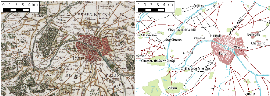
To overcome these problems, Perret and co compared different versions of the same areas drawn at different times to minimize potential distortions. They also developed a program that predicts the most likely network of roads inside a town when this is not shown.
In addition, they developed various ways of automatically testing the resulting networks to see how realistic they were. For example, a road network should be more or less entirely connected since any unconnected regions would effectively be “islands.” So examining the size and distribution of the connected parts of the network should be an indication of how realistic it is.
This process showed that the vast majority of the roads in the digitized maps form a single network. However, the map also contained island networks, but these generally correspond to reasonable features such as the island of Jersey or the network of paths through a forest which are unconnected to roads and so on.
The resulting map clearly shows the road network in France in the second half of the 18th century.
That’s interesting work that should appeal to a wide range of researchers. Urban planners are particularly interested in understanding how road networks influence the way towns and cities spread. Network scientists need good data to understand the idiosyncrasies of network evolution in the real world. And of course, historians now have a new way to access and study the geography of the region at that time.
The digitized maps are freely available here.
And there is more to come from projects like this. There is ongoing work to digitize the maps of Paris throughout its history and the New York Public Library is currently digitizing various historical maps of New York to name just two. All this work is turning history into a computational science that has huge potential to change the way we access and think about the past. Louis XV would have been amazed.
Ref: arxiv.org/abs/1509.09055 : Roads and Cities of 18th Century France
Keep Reading
Most Popular
Large language models can do jaw-dropping things. But nobody knows exactly why.
And that's a problem. Figuring it out is one of the biggest scientific puzzles of our time and a crucial step towards controlling more powerful future models.
The problem with plug-in hybrids? Their drivers.
Plug-in hybrids are often sold as a transition to EVs, but new data from Europe shows we’re still underestimating the emissions they produce.
Google DeepMind’s new generative model makes Super Mario–like games from scratch
Genie learns how to control games by watching hours and hours of video. It could help train next-gen robots too.
How scientists traced a mysterious covid case back to six toilets
When wastewater surveillance turns into a hunt for a single infected individual, the ethics get tricky.
Stay connected
Get the latest updates from
MIT Technology Review
Discover special offers, top stories, upcoming events, and more.