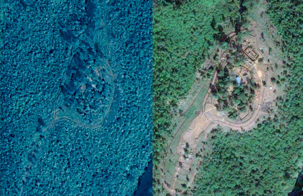
Credit: GeoEye (Before image, left); DigitalGlobe (after image, right)
These “before” and “after” satellite images–ordered and analyzed by the American Association for the Advancement of Science–show the expansion of a military encampment in eastern Burma between November 11, 2000 (left), and December 13, 2006 (right); such camps support military crackdowns. The images corroborated reports from a human-rights group.
The image pairing was one of several successes for the association’s project on geospatial technologies and human rights, which in recent years has helped document hundreds of human-rights violations by comparing field notes with satellite images. Among other things, the project documented the existence of forced-relocation camps where 23,700 people were said to be living, as well as the expansion of refugee camps in Thailand near the Burmese border, to which victims are fleeing.

Q&A
Lars Bromley
A satellite sleuth explains how images illuminate abuses
TR: How easy is it to get satellite pictures in the area you need?
Lars Bromley: Sometimes you get lucky, and a lot of times you don’t. When the protests in Burma started [in October 2007], we submitted requests for imagery right away, because we wanted to see the military response. But by the time we got the imagery, everything was done.
TR: Where are you getting these images?
LB: Right now, there are only three satellites in orbit I can draw from, owned by DigitalGlobe, Geoeye, and ImageSat International. I can get two–four at most–images from a given location within a couple of weeks. And they don’t do everything I tell them. The amount of imagery I’m buying–it’s chump change.
TR: What does the future hold for this kind of watchdog work?
LB: There are at least two new satellites that should be operational by March or so. They can collect more images than current ones, and they have higher resolution. The best current commercial resolution is 60 centimeters. The new satellites will have a resolution of 50 centimeters. And we really do find that even a 5- or 10-centimeter improvement is significant.
We are starting to get to the point where we have some sort of actual observation system. No matter where or when something happens in the world, we can more quickly get multiple images.
Lars Bromley heads the Geospatial Technologies and Human Rights Project at the American Association for the Advancement of Science. Image credit: Benjamin Somers.
Keep Reading
Most Popular
Large language models can do jaw-dropping things. But nobody knows exactly why.
And that's a problem. Figuring it out is one of the biggest scientific puzzles of our time and a crucial step towards controlling more powerful future models.
The problem with plug-in hybrids? Their drivers.
Plug-in hybrids are often sold as a transition to EVs, but new data from Europe shows we’re still underestimating the emissions they produce.
How scientists traced a mysterious covid case back to six toilets
When wastewater surveillance turns into a hunt for a single infected individual, the ethics get tricky.
Google DeepMind’s new generative model makes Super Mario–like games from scratch
Genie learns how to control games by watching hours and hours of video. It could help train next-gen robots too.
Stay connected
Get the latest updates from
MIT Technology Review
Discover special offers, top stories, upcoming events, and more.