Sponsored
Mapping the way to climate resilience
The visualization and analysis of spatial data are helping solve some of the world’s most pressing problems.
In association withEsri
Many companies don’t know yet how climate change will change their business, but more are taking the inquiry seriously, signaling a new reality—one that calls any companies don’t yet know how for guarding against systemic risk while protecting customer relationships and corporate reputations. Recognizing that reducing carbon emissions is essential to combat climate change, AT&T has made a commitment to become carbon-neutral by 2035.
Mapping the way to climate resilience
“We just know it’s the right thing to do for our customers and—I say this from years of doing risk management— it’s good, basic risk management,” says Shannon Carroll, director of global environmental sustainability at AT&T. “If all indications are that something is going to happen in the future, it’s our responsibility to be prepared for that.”
Globally, leaders from government, business, and academia see the urgency. The World Economic Forum Global Risks Report 2021 names extreme weather due to climate change and human-driven environmental damage among the most pressing risks of the next decade. When citing risks with the highest impact, those surveyed listed climate action failure and other environmental risks second only to infectious diseases.

AT&T is taking action with its Climate Resilience Project, using spatial data analysis and location information to tackle the complex problem of how increasingly powerful storms could affect infrastructure such as cell towers and the telecom’s ability to deliver service to its customers. “Spatial analysis is this way of going beyond what we visually see,” explains Lauren Bennett, head of spatial analysis and data science at Esri, a geographic information systems (GIS) company. “It’s going beyond a data-driven approach and much more into a knowledge-driven approach.”
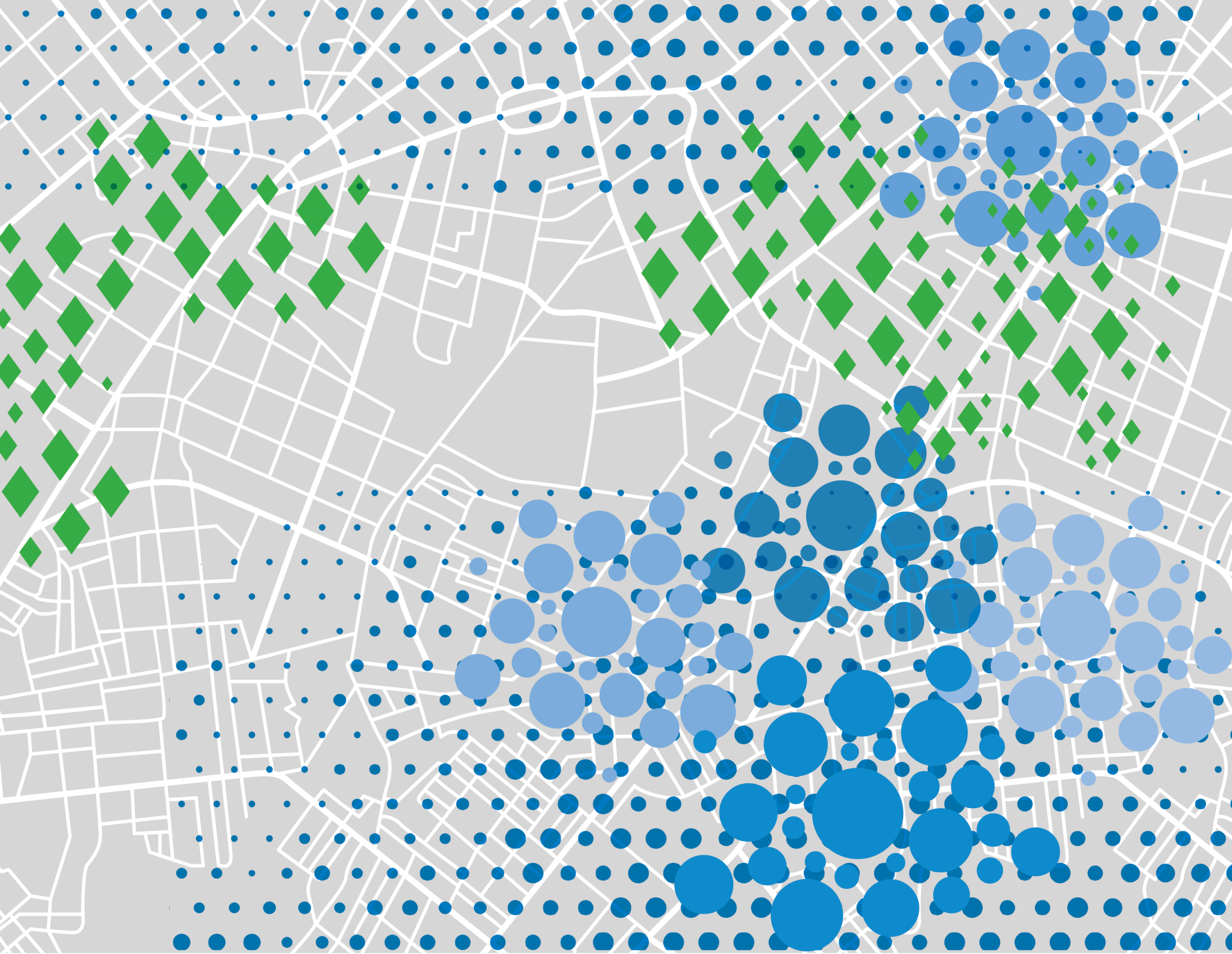
To better understand its vulnerability, AT&T collaborated with the US Department of Energy’s Argonne National Laboratory. Their joint mission was to identify risks to the company’s infrastructure and real estate based on historical weather events and predictive modeling. They fed company asset data and climate data from the lab into a GIS, which can layer volumes of disparate information in the context of location for visualization and analysis. The output of all this multifaceted information is referred to as location intelligence.
“When we talk about GIS,” says Jay Theodore, chief technology officer at Esri, “we are able to expand to the scale of the world for solving global problems but also shrink down and bring a magnifying glass to something in the immediate vicinity and study that, too.”
AT&T plans for the future today
“Everybody needs a plan for climate change,” says Carroll. AT&T’s plan centers on advanced spatial analytics to see how destructive storms and other climate-change-driven phenomena across the United States will affect nearby infrastructure. Ultimately, businesses will be able to forecast where, and to what degree, climate events might affect customers. AT&T understands that without a resilient network, the broadband connectivity required to close the digital divide is also at risk. “Our number one priority is making sure we have a network that’s going to service our customers 20, 30 years from now,” Carroll says.
The foundation of AT&T’s GIS is a map identifying the locations of the company’s offices and stores, cell towers and servers, storage facilities, underground and above-ground wires and conduits, and other infrastructure. Layered on top of the map is the climate change data analyses that AT&T commissioned from Argonne. Together, Argonne and AT&T created the Climate Change Analysis Tool, which can predict the frequency, extent, and location of flooding, high-speed winds, wildfires, and drought about 30 years into the future.
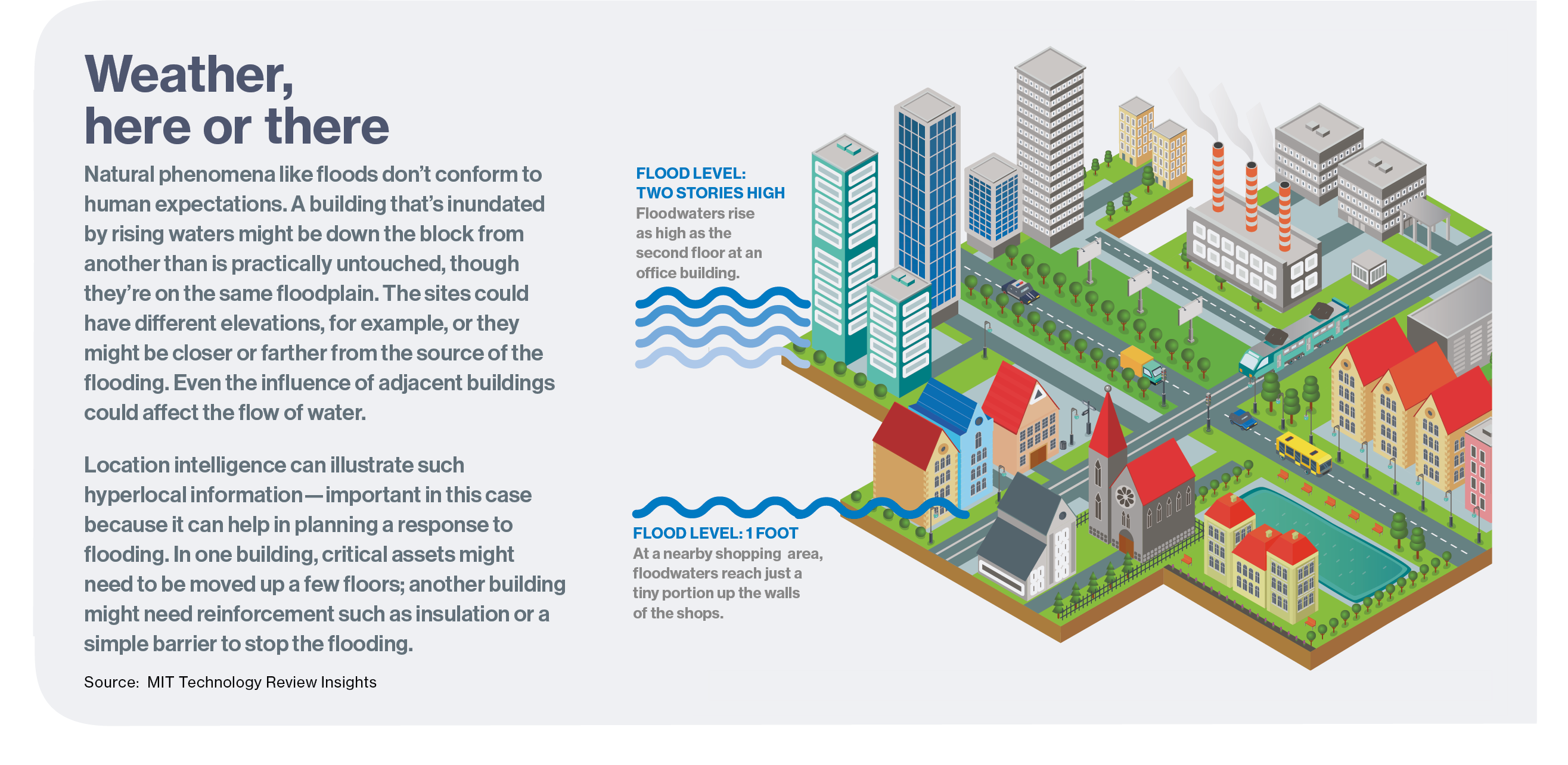
Location intelligence visualizes climate-related risks to AT&T’s infrastructure, based on contextual information and science-actuated knowledge. Without the GIS’s spatial correlation of Argonne’s climate analyses to the corporate map, AT&T would have a jumble of difficult-to-interpret data, arrayed in separate spreadsheets and databases—in all, more than 500 billion pages of text. As Theodore explains, “If you want the complete picture, if you want to make the right decisions, you have to bring in location.”
For example, as a pilot, the AT&T and Argonne team used their Climate Change Analysis Tool to look at regions in the US Southeast susceptible to floods and high winds. “Getting some of the best available climate data from Argonne National Lab and then overlaying that into a GIS so you can visualize it—that in and of itself is very exciting,” Carroll says. With an exceptional degree of detail, executives could determine how infrastructure in four states—Georgia, North Carolina, South Carolina, and Florida—could be affected by, for example, a 50-year storm event in the coming decades. “Not every [asset] is at the same risk, even if they’re close together,” Carroll points out. This assessment can prove helpful for more precise planning—for example, the allocation of resources to potentially relocate, remodel, or reinforce infrastructure against potential damage.
One key tenet of the telecom’s sustainability effort involves a tactic many companies avoid—sharing data. AT&T teams working on climate risk analysis decided to make their data available to everyone. They publicized access through press releases and social media channels, encouraging people and groups to download it. “When it comes to building climate resilience, you don’t compete. This is where you collaborate,” Carroll says. “We encourage everybody to use this data because it doesn’t do us any good if we’re resilient but the rest of our value chain is not.”
Download the full report.
Deep Dive
Climate change and energy
The problem with plug-in hybrids? Their drivers.
Plug-in hybrids are often sold as a transition to EVs, but new data from Europe shows we’re still underestimating the emissions they produce.
Harvard has halted its long-planned atmospheric geoengineering experiment
The decision follows years of controversy and the departure of one of the program’s key researchers.
Why hydrogen is losing the race to power cleaner cars
Batteries are dominating zero-emissions vehicles, and the fuel has better uses elsewhere.
Decarbonizing production of energy is a quick win
Clean technologies, including carbon management platforms, enable the global energy industry to play a crucial role in the transition to net zero.
Stay connected
Get the latest updates from
MIT Technology Review
Discover special offers, top stories, upcoming events, and more.