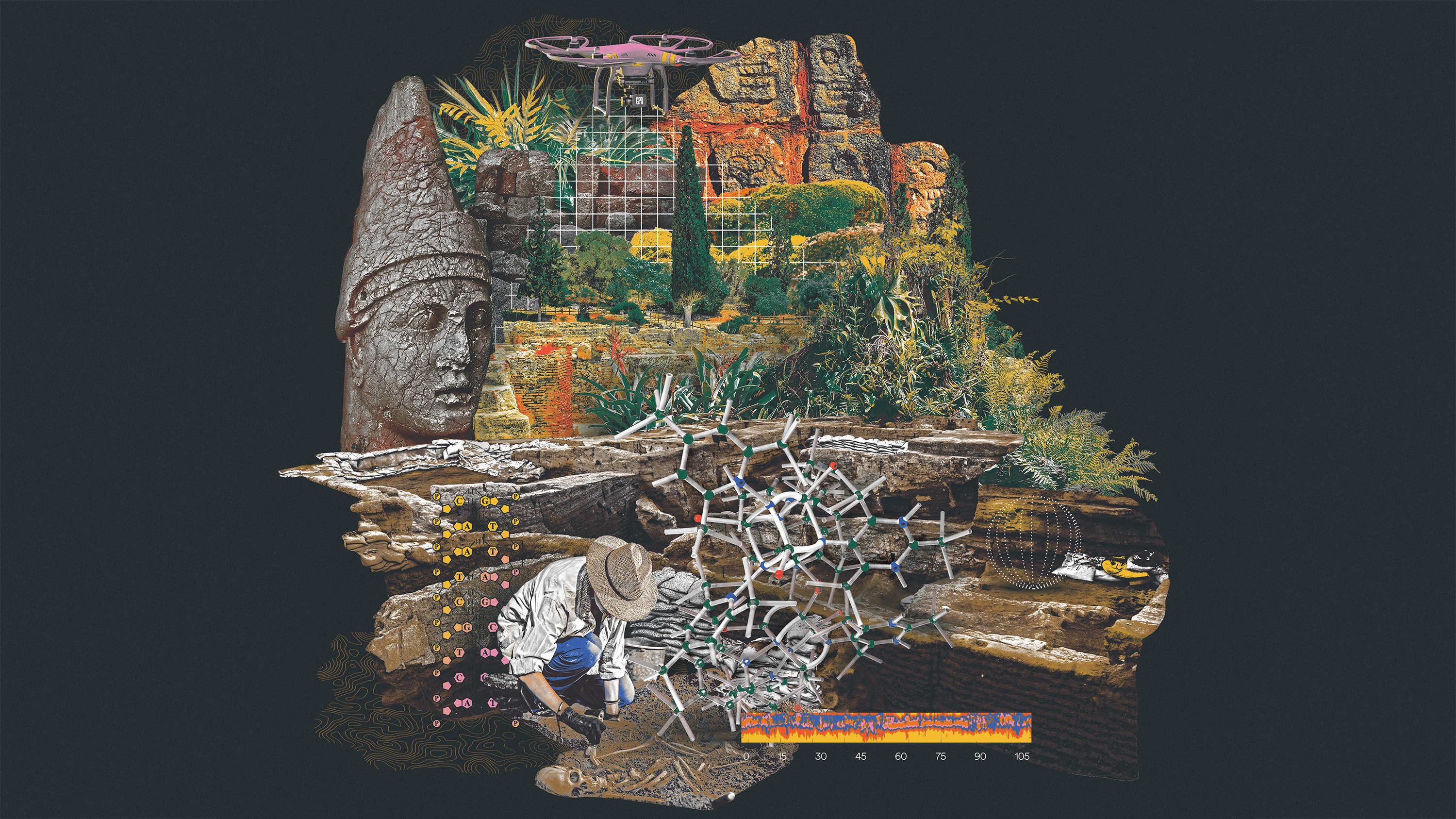
How technology helped archaeologists dig deeper
Digital tools can help us understand ancient cities and the people who lived in them.
Construction workers in New York’s Lower Manhattan neighborhood were breaking ground for a new federal building back in 1991 when they unearthed hundreds of coffins. The more they dug, the more they found—eventually uncovering nearly 500 individuals, many buried with personal items such as buttons, shells, and jewelry. Further investigation revealed that the remains were all between 200 and 300 years old, and they were all African and African-American.
This discovery came at an inflection point in scientific history. Breakthroughs in chemical and genetic analysis allowed researchers to figure out where many of these people had been born, what kinds of physical challenges they faced, and even what route they took from Africa to get to North America. The site, known as the African Burial Ground, became one of the best-known archaeological discoveries in the country and is now a national monument.
Joseph Jones, an anthropologist at the College of William & Mary and one of the site’s investigators, told me that the science matured even while his team was still excavating. At the start of their dig, they analyzed skeletal remains using the same techniques that archaeologists had used for almost a century, measuring the size of bones and looking at damage to them to infer details of people’s lives. Today, though, the team is using modern techniques that previous generations of researchers only dreamed of: using lasers to slice micro-thin pieces of tooth enamel so the isotopes trapped within can be analyzed; sequencing ancient DNA to connect people who died centuries ago to their descendants.
The African Burial Ground was uncovered at a moment of cultural discovery as well. Historians were investigating the role enslaved people played in building northern cities, while Black scholars like Henry Louis Gates Jr. and authors like Toni Morrison were centering the roles of African-Americans in US history.
By using remote sensing technologies like lidar, researchers can uncover an entire city grid, giving us a better picture of what it would have been like to walk through neighborhoods and peek into shops.
Scientific analysis at the site added persuasive data to these social movements and changed the way many Americans viewed their nation’s founding. It revealed that enslaved people from Africa built many of the cities that Americans still live in today—in the North and the South. And it showed how we went from being a nomadic species that traveled in small bands to sharing tightly packed habitats with millions of other people.
The African Burial Ground project was among the first to use a new constellation of “bioarchaeology” tools that went way beyond the traditional pickaxes and brushes. But this was simply the first stage of a much broader archaeological revolution that brought scientists and humanities scholars together to generate data about our ancestors. Today, researchers supplement bioarchaeology with 3D photography, lidar, satellite imagery, and more.
Sometimes called “data archaeology,” this kind of high-tech exploration is well suited to the study of urban history. By using remote sensing technologies like lidar, researchers can uncover an entire city grid, giving us a better picture of what it would have been like to walk through neighborhoods and peek into shops. This kind of data makes accurate digital re-creations possible, which means historians can turn a remote, inaccessible site into something that anyone can visit online.
This data democratizes history, too: scholars can now examine hundreds, if not thousands, of remains and process large data sets to gain insight into the experiences of ordinary people—not just the lucky few who owned land, emblazoned their names on monuments, or held public office.
Tooth telling
Data archaeology is particularly good for historians studying cities because urban places often hold the stories of immigrants who might be otherwise difficult to trace. Bioarchaeologist Michael Blakey, who has led the African Burial Ground project since the early 1990s, said his team would never have known where people in the cemetery came from if they hadn’t been able to do several kinds of chemical analysis on their tooth enamel. Because this enamel is built up in layers as humans mature, chemists can study a cross-section of the tooth and learn what substances people were exposed to as children. It’s a bit like analyzing tree rings, where each layer of enamel represents a period of the person’s life.
Immediately, they found a sharp dividing line between people born in Africa and people born in the Americas: lead. Though African civilizations worked with a range of metals, lead was almost exclusively used by Europeans, for things like pipes and pewter dishes. Anyone who had lead in childhood tooth enamel was almost certainly born locally.
As the science developed, Blakey’s group also used a technique called strontium isotope analysis to learn more about where people had come from. When people eat and drink in a specific area for a long time, their teeth absorb a small amount of strontium, an element that leaches out of the rocky ground into food and drinking water. Strontium from older landmasses has a slightly different chemical signature than strontium from newer ones, so looking at the isotopes in people’s tooth enamel lets researchers determine roughly where they lived throughout their lifetimes.
Tools of the trade
Ground-penetrating radar
uses high-frequency radio waves that pass through the Earth’s surface, bump into objects and structures below, and bounce back to a receiver above ground that records these patterns. Already common in geology, archaeologists have expanded their use of it in recent years.
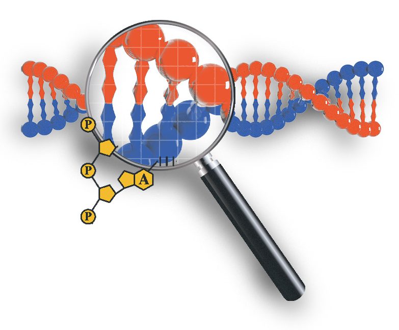
DNA sequencing
has revolutionized archaeology by allowing for detailed analysis of remains that can unveil a person’s family history and migration patterns. Imagine at-home genomic tests, but for bones.
Photogrammetry
involves capturing 3D information about a location or object with a range of techniques, including radar and sonar. It can also include lidar, a laser system that measures reflections to judge distance, and is used in everything from laser guidance to some autonomous cars.
Isotope analysis
is used in archaeology to trace the history of an item. By looking for chemical signatures in made objects and organic material, such as the bones at the African Burial Ground, this technique can determine their age and provenance.
Studying this, explained Blakey, allowed his team to discover that some of the people buried in modern-day New York had spent early childhoods in Africa but then lived for some time during adolescence in the Caribbean, where enslaved men were often sent for “seasoning” or, as Blakey put it, “breaking down.” The shape of a diaspora was revealed in a single tooth.
Archaeologists have since used this technique to explore how cities have developed throughout the world. As a result, we now know that ancient Rome was full of immigrants from across Europe and North Africa.
In the Americas, archaeologists are looking at how indigenous cities like Cahokia in today’s southern Illinois were settled by people born elsewhere. Even a 9,000-year-old city like Çatalhöyük in central Turkey was populated by people who came from afar.
From this research, we now understand that immigrants have been building and living in cities for as long as cities have existed. Some, like the enslaved people in New York, came against their will. Others came on their own, seeking work or a better life, the same way hopeful immigrants do today.
Dodging damage
While bioarchaeological data can reveal a lot about who lived in a city, sophisticated sensor data can illuminate exactly where they lived and what kind of work they did. That’s where ground-penetrating radar, or GPR, comes into play. One of the great tragedies at many buried sites is that digging often destroys the layers in between the surface and the deepest objects—even though they may be valuable in their own right. Like traditional radar, GPR emits radio waves and measures how they bounce back in order to locate objects, shooting them at the ground to help avoid unwanted destruction.
At Pompeii, for example, researchers recently used this type of radar to help target areas for exploration in a section of the city that has remained buried under ash for 2,000 years. Only two-thirds of Pompeii has been dug up over the past three centuries, and for most of that time, the job was done with pickaxes. But researchers are approaching the final third of the city with as many high-tech tools as possible.
In early 2021, their care paid off: scholars uncovered a beautifully preserved bar where workers would have enjoyed a quick meal and some wine. Even more stunning was the discovery of a rare, intact ceremonial chariot that would have been used in parades and helped model what traffic would have looked like on Roman streets.
Ground-penetrating radar can also reveal multiple levels of history. A recent survey of a palatial house at Pompeii, for example, showed that it was built on the foundations of a much older building.
This suggests that the neighborhood was an enclave for the wealthy even before Romans occupied the city starting around 89 BCE. A look underground revealed that workers rebuilt the house, enlarging its gardens considerably after a massive earthquake in 62 CE. According to Cornell classicist Caitlín Barrett and her colleagues, their findings “promise to rewrite the history of one of the oldest and most politically prominent neighborhoods in Pompeii.”
Unfortunately, not all archaeology can be done with remote sensing. Because most cities are built in layers, with older structures gradually buried beneath the new, excavators must destroy the upper layers to reach further back in time. That’s why photogrammetry, the practice of capturing 3D information with sonar, lidar, and digital cameras, is now de rigueur at almost every major excavation site.
Using these methods, researchers can record details of a structure down to the millimeter and use software to re-create them.
This is especially important at sites like Çatalhöyük, where researchers must dig through an upper layer of the city to reach older structures below. By first scanning those upper layers, scholars can make it possible to virtually revisit any structures that had to be destroyed.
Virtual visits
Data from photogrammetry also provided the backbone for the award-winning Virtual Angkor project, which re-creates the city that was the capital of Southeast Asia’s Khmer Empire for 500 years until it was sacked in 1431 CE. A collaboration between Monash University’s SensiLab, Flinders University, and the University of Texas at Austin, Virtual Angkor uses 3D scans from areas around the Buddhist temple of Angkor Wat to create breathtaking visualizations—some video, some still—of what ordinary people would have seen when they visited the city in the 1300s.
Virtual Angkor was also made possible by another breakthrough in archaeological data gathering. For hundreds of years, Angkor’s layout remained hidden beneath the jungle. That changed in the early 2010s when Damian Evans, an archaeologist at the French School of the Far East, and his team used helicopter-mounted lidar to map around the temple enclosures. What they found changed the world’s understanding of this tropical city.
When we look out over the gleaming skyscrapers and vast sprawl of today’s megacities, it’s easy to forget the old bones that lie beneath.
Lidar works by bouncing laser beams off the surface of the ground and back to a receiver; the timing of those reflections indicates how far the light traveled before it hit something. It was the perfect tool for revealing the roads, house foundations, and pools that once covered the landscape. With lidar maps, archaeologists could at last verify that Angkor had been home to nearly a million people at its height—a claim that had been widely disputed.
Virtual Angkor used these maps to create a detailed grid of the city’s downtown, complete with pictures of modest neighborhoods where manual laborers and immigrants would have lived. Because these people lived in wooden houses that decomposed long ago, it was hard for past generations of archaeologists to know where—or even if—people lived in the areas surrounding Angkor’s stone palace. But thanks to the lidar surveys, today’s archaeologists can now see many hectares of neat foundations lined up along roads.
Photogrammetry can tell us about the Khmer Empire’s art and architecture, but lidar tells us about the lives of the people who built this legendary metropolis. By using advanced technologies to develop new kinds of data sets, archaeologists at the African Burial Ground also centered the lives of city builders. And the isotope analysis that revealed New York’s forgotten past has also shown us the immigrants who built ancient Roman cities.
When we look out over the gleaming skyscrapers and vast sprawl of today’s megacities, it’s easy to forget the old bones that lie beneath. But the more science advances, the closer we get to appreciating who built our world, and what their lives were really like.
Annalee Newitz’s latest book is Four Cities: A Secret History of the Urban Age.
Deep Dive
Humans and technology
Building a more reliable supply chain
Rapidly advancing technologies are building the modern supply chain, making transparent, collaborative, and data-driven systems a reality.
Building a data-driven health-care ecosystem
Harnessing data to improve the equity, affordability, and quality of the health care system.
Let’s not make the same mistakes with AI that we made with social media
Social media’s unregulated evolution over the past decade holds a lot of lessons that apply directly to AI companies and technologies.
Stay connected
Get the latest updates from
MIT Technology Review
Discover special offers, top stories, upcoming events, and more.