Sponsored
Data-driven humanitarianism
The world’s largest human aid organization is on a mission to solve world hunger by 2030. The key: geospatial technology.
In association withEsri
It’s one of the most beautiful places on Earth, but its people are among the most vulnerable. Afghanistan’s snowy mountains and fertile foothills give way to arid plateaus, offering a contrast often described as stark and gorgeous. The nexus of ancient East-West trade routes, this landlocked country hosts many languages, artisan traditions, and centuries of influence from Islamic, Buddhist, and Hindu customs. It’s also a place where an estimated 12.4 million are living in hunger, and where droughts, floods, and conflict often make access routes impassable for humanitarian convoys.
Working to end hunger for the people of Afghanistan, despite climate change and conflict challenges, is the World Food Programme (WFP). In 2020, the Norwegian Nobel Committee awarded the Nobel Peace Prize to WFP for these efforts. As the world’s largest humanitarian organization addressing hunger and promoting food security for 100 million people in 88 countries, WFP set a goal for zero world hunger by 2030.
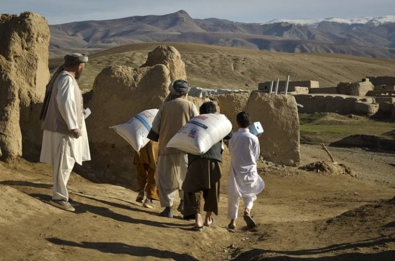
“Saving lives is not enough,” says Lara Prades, who leads WFP’s geospatial unit. “We also need to change lives.” Most people think WFP is “just dropping aid from planes in the event of a hurricane,” but there’s another side to its mission. “It actually is participatory, and we work with communities to improve nutrition and food security.”
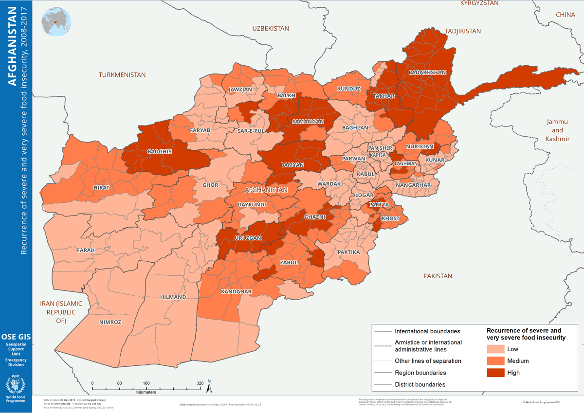
Prades speaks of a “dual mandate”—respond to immediate food scarcity and pinpoint underlying problems to create long-term solutions. Prades and her team start with smart maps showing near real-time data about weather, supply routes, and road conditions. They perform advanced analytics to specify the exact challenges for each region. WFP outreach plans are reinforced by face-to-face conversations with local people, discussing real-world implications of what appears on the map.
In the central Afghanistan city of Bamiyan, celebrated for two monumental Buddha statues carved into the side of a cliff in the sixth century and destroyed by the Taliban in 2001, Prades spent time drinking tea with people who live there. “If the map is telling us this area is highly vulnerable, and on top of that, they have had these floods and droughts,” Prades says, “we go and meet the people and talk to them.”
These conversations validate what the maps and analyses say, and they help WFP planners understand the best intervention for each region, even accounting for seasonal or yearly variations. It’s a data and discovery process crucial in Afghanistan and around the world as WFP aims to end world hunger within this decade.
Mapping root causes
The advances in geospatial technology to map, manage, and automate the analysis of food insecurity data come at a time when the frequency and intensity of hunger-related emergencies is escalating because of climate change.
In the days and hours leading up to a heavy storm or weather catastrophe, WFP teams use maps from a geographic information system (GIS) to quickly determine who will need support, where, and how to reach them. Outside of emergency response, they apply GIS analysis to detect underlying threats—such as floods and droughts that have degraded farmland or conflict that have closed transportation routes.
“We’re doing this in a quite sophisticated fashion—how we combine geospatial data to identify where to position long-term programs for tackling recurring food insecurity and also disaster reduction,” Prades says.
Even with advanced mapping capabilities, the outreach depends on local touchpoints. Prades and her team will ask people, “what worries you the most?” It may be firewood or goat vaccinations, a fear of camels getting sick, or preparations for the maize harvest. The concerns become data layers, added to smart maps to recognize trends or hotspots, and point to possible mitigation efforts.
“You need to see the linkages,” Prades says, “to see all the connections of how that is translating into actual benefits for the people who we are trying to help.”
WFP staff use this location intelligence to determine where to deliver food rations and position programs such as flood protection, irrigation systems, or plant nurseries. For the people of Afghanistan, smart maps also help WFP staff negotiate access routes with government officials or non-state armed groups to reach far-flung or isolated regions.
Democratizing insights
When Prades started with WFP in 2008, the organization was using GIS for basic data visualization to map the results of food security assessments. Now, geospatial technology supports advanced analytics generated by a modern GIS and web applications for complex logistics and near real-time data sharing.
“We call this a spatial data infrastructure,” Prades says. “It’s really allowing us to store, process, and share all the geospatial data and make it accessible to all levels of the organization. We are all working with the same data.”
On any given day, WFP coordinates an average of 5,600 trucks, 50 ocean shipments, 92 aircraft, and 650 warehouses across the globe. Operational staff tap the geospatial infrastructure to coordinate aid deliveries.
“We produce reference maps with the transportation network for logistics staff to plan their routes and see what roads they can access with what trucks,” says Thierry Crevoisier, GIS officer at WFP headquarters in Rome.
Teams on the ground constantly provide new information—what’s happening with the roads, where are the schools and markets, where are security challenges. The new data syncs across routing applications for safe aid delivery. Live maps and dashboards link to automatic early warning systems set to trigger intervention before a weather event. Most remarkable to Prades is how the technology “is not driven by the technical people, but instead by the users, by the operators.”
People in each country served by WFP accept accountability for updating information or bringing in open source data, such as conflict maps. The live updates to dashboards and apps allow WFP workers to plan against difficulties and lower risks when delivering aid or conducting field assessments.
Proactive and real-time logistics
When floods recently struck South Sudan, WFP was working to deliver food to people stranded by floods in Indonesia and the Philippines. With climate-related events on the rise, Prades highlighted increased calls for preliminary impact analysis to make resources ready when and where disasters strike. This measure would reduce scenarios where WFP teams are stretched thin or mobilizing in reactive ways.
Geospatial technology enables such analysis, overlaying an anticipated storm path or earthquake epicenter with the locations of vulnerable populations before an event. In the aftermath, WFP teams rely on those same smart maps—loaded with local data and satellite imagery—to route supplies.
“The humanitarian world is changing,” Prades says. “Once we know there is an event coming, we have a window of two weeks. What kind of interventions can we already implement in those two, three weeks to be able to mitigate the impact of the upcoming shock?”
In Mozambique, a country that experiences major flooding every few years, Prades and her team created flood-hazard models showing potential damage and people affected. The models can be run against security assessments and road conditions as well as WFP resources. Seeing this location-based insight ahead of actual flooding moved WFP planners from a mindset of response to one of preparedness.
“They start shifting the way they think,” Prades says. “Where can we pre-position certain stocks based on the flood-risk areas? Where are the routes that are most efficient to take when this happens? Normally people tend to be very reactive—we don’t tend to think before the event happens.”
The possibility of zero hunger
The covid-19 pandemic deepened food insecurity for the world’s most vulnerable people, those already racked by conflict and climate-related disasters. WFP estimates 96 million more people in 54 countries reached acute hunger levels in 2020, adding to the 137 million accounted for in 2019.
In its mission to end world hunger, WFP aligns with one of the Sustainable Development Goals developed by United Nations and adopted in 2015 by the global community.
Though the pandemic has made this goal more difficult, Prades sees the collaborative work of multiple agencies as a way to strengthen the fight. And the geospatial tools she builds can empower that collaboration while continuing to serve the dual mandate of meeting immediate needs and addressing underlying causes.
“It’s a different approach, and it’s quite promising,” Prades says. “My dream is there’s no more hunger.”
This content was produced by Insights, the custom content arm of MIT Technology Review. It was not written by MIT Technology Review’s editorial staff.
Deep Dive
Humans and technology
Building a more reliable supply chain
Rapidly advancing technologies are building the modern supply chain, making transparent, collaborative, and data-driven systems a reality.
Building a data-driven health-care ecosystem
Harnessing data to improve the equity, affordability, and quality of the health care system.
Let’s not make the same mistakes with AI that we made with social media
Social media’s unregulated evolution over the past decade holds a lot of lessons that apply directly to AI companies and technologies.
Stay connected
Get the latest updates from
MIT Technology Review
Discover special offers, top stories, upcoming events, and more.